PDS logoPlanetary Data System
PDS Information
Find a Node - Use these links to navigate to any of the 8 publicly accessible PDS Nodes.

This bar indicates that you are within the PDS enterprise which includes 6 science discipline nodes and 2 support nodes which are overseen by the Project Management Office at NASA's Goddard Space Flight Center (GSFC). Each node is led by an expert in the subject discipline, supported by an advisory group of other practitioners of that discipline, and subject to selection and approval under a regular NASA Research Announcement.
Click here to return to the Photojournal Home Page Click here to view a list of Photojournal Image Galleries Photojournal_inner_header
Latest Images  |  Spacecraft & Technology  |  Animations  |  Space Images App  |  Feedback  |  Photojournal Search  

PIA00294: Europa's Active Surface
 Target Name:  Europa
 Is a satellite of:  Jupiter
 Mission:  Galileo
 Spacecraft:  Galileo Orbiter
 Instrument:  Solid-State Imaging 
 Product Size:  1070 x 868 pixels (w x h)
 Produced By:  JPL
 Producer ID:  P47169 MRPS74960
 Addition Date:  1997-09-07
 Primary Data Set:  Galileo EDRs
 Full-Res TIFF:  PIA00294.tif (732.4 kB)
 Full-Res JPEG:  PIA00294.jpg (161.1 kB)

Click on the image above to download a moderately sized image in JPEG format (possibly reduced in size from original)

Original Caption Released with Image:

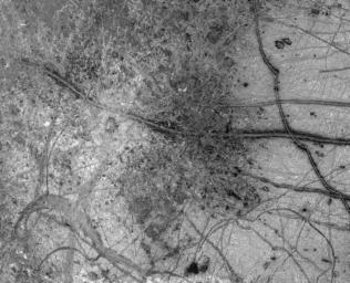
A newly discovered impact crater can be seen just right of the center of this image of Jupiter's moon Europa returned by NASA's Galileo spacecraft camera. The crater is about 30 kilometers (18.5 miles) in diameter. The impact excavated into Europa's icy crust, throwing debris (seen as whitish material) across the surrounding terrain. Also visible is a dark band, named Belus Linea, extending east-west across the image. This type of feature, which scientists call a 'triple band,' is characterized by a bright stripe down the middle. The outer margins of this and other triple bands are diffuse, suggesting that the dark material was put there as a result of possible geyser-like activity which shot gas and rocky debris from Europa's interior. The curving 'X' pattern seen in the lower left corner of the image appears to represent fracturing of the icy crust and infilling by slush which froze in place. The crater is centered at about 2 degrees north latitude by 239 degrees west longitude. The image was taken from a distance of 156,000 kilometers (about 96,300 miles) on June 27, 1996, during Galileo's first orbit around Jupiter. The area shown is 860 by 700 kilometers (530 by 430 miles), or about the size of Oregon and Washington combined. The Galileo mission is managed by NASA's Jet Propulsion Laboratory.

Image Credit:
NASA/JPL

Image Addition Date:
1997-09-07