- Original Caption Released with Image:
-
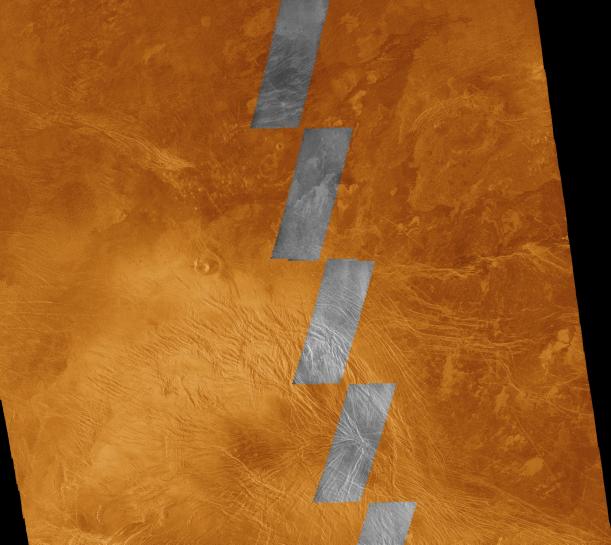
This image compares Magellan data acquired in August 1990 during the initial test of the radar system (black and white insets) with data acquired by the spacecraft in April 1991 (color background). The area is in the southern hemisphere of Venus, and represents an area about 540 kilometers (330 miles) on a side, centered on latitude 35 degrees south and longitude 294 degrees east. The Magellan radar illuminates the surface from the left. The northern and eastern parts of the area consist of plains which appear moderately dark to dark on the radar image because they are relatively smooth at a scale comparable to the wavelength of the radar, 12.5 centimeters (about 5 inches). The bright terrain in the southwestern part of the image is about 500 to 700 meters (1640 to 2300 feet) higher than the plains; it is characterized by abundant faults and fractures, which appear as straight to gently curved bright lines. Many of these linear features are large enough to infer that they are grabens, which are troughs bounded on both sides by faults. However, many of them are too narrow to determine if they are faults or simply fractures that have roughened the surface. This elevated faulted and fractured region is part of a large east-west elongated ridge mapped by the Pioneer Venus radar altimeter; the portion shown here is about midway between Themis Regio and Tefnut Mons. The plains are probably underlain by volcanic lavas. The various shades indicate that minor differences in surface roughness are present, and these may be used to map out the distribution of different lavas. The small, bright patches on the plains represent places where the lava surfaces are relatively rough. Just left of the center of the image is a sharply defined volcanic crater about 15 kilometers (9 miles) in diameter. Immediately north of this crater are numerous round spots about 204 kilometers (102 miles) across that are small volcanic domes.
- Image Credit:
-
NASA/JPL
Image Addition Date: -
1996-02-01
|
 Planetary Data System


