PDS logoPlanetary Data System
PDS Information
Find a Node - Use these links to navigate to any of the 8 publicly accessible PDS Nodes.

This bar indicates that you are within the PDS enterprise which includes 6 science discipline nodes and 2 support nodes which are overseen by the Project Management Office at NASA's Goddard Space Flight Center (GSFC). Each node is led by an expert in the subject discipline, supported by an advisory group of other practitioners of that discipline, and subject to selection and approval under a regular NASA Research Announcement.
Click here to return to the Photojournal Home Page Click here to view a list of Photojournal Image Galleries Photojournal_inner_header
Latest Images  |  Spacecraft & Technology  |  Animations  |  Space Images App  |  Feedback  |  Photojournal Search  

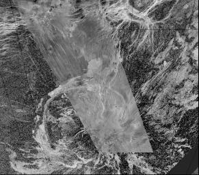
PIA00217: Arecibo/Magellan Composite of Quetzalpetlatl Corona
 Target Name:  Venus
 Is a satellite of:  Sol (our sun)
 Mission:  Magellan
 Spacecraft:  Magellan
 Instrument:  Imaging Radar
 Product Size:  8131 x 7169 pixels (w x h)
 Produced By:  JPL
 Producer ID:  P37047 P37236
 Addition Date:  1997-01-16
 Primary Data Set:  Magellan MIDRs
 Full-Res TIFF:  PIA00217.tif (34.49 MB)
 Full-Res JPEG:  PIA00217.jpg (9.458 MB)

Click on the image above to download a moderately sized image in JPEG format (possibly reduced in size from original)

Original Caption Released with Image:

This composite image was created by inserting approximately 70 orbits of Magellan data into an image obtained at the Arecibo, Puerto Rico radiotelescope and shows a geologically complex region in the southern hemisphere of Venus. The region is centered on 65 degrees south, 359 degrees east and is about 1500 x 1500 km (900 x 900 miles) in extent. The large oval feature in the lower half of the image is Quetzalpetlatl Corona, approximately 700 km (420 miles) in diameter. Coronae are circular to oval regions defined by an annulus of ridges and are centers for tectonic and volcanic activity. Tectonic activity is largely observed in a relatively narrow rim region, which in this image is defined by a complex lineated terrain that surrounds much of the corona. Bright and dark volcanic flows are seen throughout the corona and surrounding terrain. Small shield volcanoes, 1-20 km (0.6-12 miles) in diameter, are seen near the southern limit of the Magellan data image. Narrow linear troughs (seen in the image as bright lines) trend to the north-northwest of Quetzalpetlatl.

Image Credit:
NASA/JPL

Image Addition Date:
1997-01-16