PDS logoPlanetary Data System
PDS Information
Find a Node - Use these links to navigate to any of the 8 publicly accessible PDS Nodes.

This bar indicates that you are within the PDS enterprise which includes 6 science discipline nodes and 2 support nodes which are overseen by the Project Management Office at NASA's Goddard Space Flight Center (GSFC). Each node is led by an expert in the subject discipline, supported by an advisory group of other practitioners of that discipline, and subject to selection and approval under a regular NASA Research Announcement.
Click here to return to the Photojournal Home Page Click here to view a list of Photojournal Image Galleries Photojournal_inner_header
Latest Images  |  Spacecraft & Technology  |  Animations  |  Space Images App  |  Feedback  |  Photojournal Search  

PIA00208: Venus - Rhea Mons Volcano
 Target Name:  Venus
 Is a satellite of:  Sol (our sun)
 Mission:  Magellan
 Spacecraft:  Magellan
 Instrument:  Imaging Radar
 Product Size:  2000 x 2000 pixels (w x h)
 Produced By:  JPL
 Producer ID:  P36546
 Addition Date:  1996-02-05
 Primary Data Set:  Magellan MIDRs
 Full-Res TIFF:  PIA00208.tif (1.267 MB)
 Full-Res JPEG:  PIA00208.jpg (429.1 kB)

Click on the image above to download a moderately sized image in JPEG format (possibly reduced in size from original)

Original Caption Released with Image:

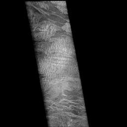
Two mosaiced pieces of Magellan image strips display the area east of the Rhea Mons volcano on Venus. This image is centered at about 32.5 degrees north latitude and 286.6 degrees east longitude. The mosaic is 47 kilometers (28 miles) wide and 135 km (81 miles) long. This region has been previously identified as "tessera" from Earth-based radar (Arecibo) images. The center of the image is dominated by a network of intersecting ridges and valleys. The radar bright north south trending features in this image range from 1 km (0.6 mile) to 3 km (1.8 miles) in length. The average spacing between these ridges is about 1.5 km (0.9 mile). The dark patches at the top of the image are smooth surfaces and may be lava flows located in lowlands between the higher ridge and the valley terrain. This image is a mosaic of two orbits obtained in the first Magellan radar test and played back to Earth to the Deep Space Network stations near Goldstone, Calif. and Canberra, Australia, respectively. The resolution of this image is approximately 120 meters (400 feet).

Image Credit:
NASA/JPL

Image Addition Date:
1996-02-05