PDS logoPlanetary Data System
PDS Information
Find a Node - Use these links to navigate to any of the 8 publicly accessible PDS Nodes.

This bar indicates that you are within the PDS enterprise which includes 6 science discipline nodes and 2 support nodes which are overseen by the Project Management Office at NASA's Goddard Space Flight Center (GSFC). Each node is led by an expert in the subject discipline, supported by an advisory group of other practitioners of that discipline, and subject to selection and approval under a regular NASA Research Announcement.
Click here to return to the Photojournal Home Page Click here to view a list of Photojournal Image Galleries Photojournal_inner_header
Latest Images  |  Spacecraft & Technology  |  Animations  |  Space Images App  |  Feedback  |  Photojournal Search  

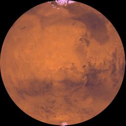
PIA00193: Latitude 90 Degrees North to 90 Degrees South and Longitude 0 Degrees to 180 Degrees
 Target Name:  Mars
 Is a satellite of:  Sol (our sun)
 Mission:  Viking
 Spacecraft:  Viking Orbiter 1
 Instrument:  Visual Imaging Subsystem - Camera A 
 Product Size:  6398 x 6398 pixels (w x h)
 Produced By:  U.S. Geological Survey
 Producer ID:  P43561
 Addition Date:  1998-06-08
 Primary Data Set:  Viking EDRs
 Full-Res TIFF:  PIA00193.tif (56.26 MB)
 Full-Res JPEG:  PIA00193.jpg (1.782 MB)

Click on the image above to download a moderately sized image in JPEG format (possibly reduced in size from original)

Original Caption Released with Image:

The coordinates of the Lambert azimuthal equal area projection are latitude 90 degrees N. to 90 degrees S. and longitude 0 degree to 180 degrees. Both polar residual ice caps are seen at top and bottom. The central part is dominated by the four largest and youngest volcanoes on Mars--Olympus, Arsia, Pavonis, and Ascraeus Montes--and by a vast system of canyons several thousand kilometers long--Valles Marineris. Directly to the northeast of Valles Marineris, several large outflow channels terminate at a dark depression, Chryse basin. The lower-right corner is marked by the large Argyre basin, defined by an expanse of light-colored plains 800 km across.

Image Credit:
NASA/JPL/USGS

Image Addition Date:
1998-06-08