- Original Caption Released with Image:
-
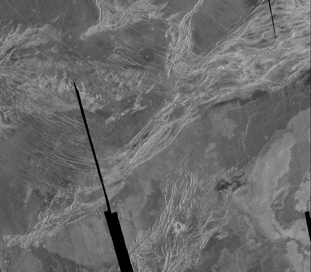
This is a Magellan full resolution radar mosaic of the Lavinia region of Venus. The mosaic is centered at 50 degrees south latitude, 345 degrees east longitude, and spans 540 kilometers (338 miles) north to south and 900 kilometers (563 miles) east to west. As with all Magellan images acquired thus far, the illumination of the radar is from the left hand side of the image. This area shows a diverse set of geologic features. The bright area running from the upper right to the lower left is interpreted as part of a belt of ridges, formed by compression and thickening of the upper layers of the planet. The areas between ridges suggest flooding by radar dark (and thus presumably) smoother lavas. The varied texture of the lavas can be seen in the mottled appearance of the plains which are cut by the ridges; brighter, rougher flows are also quite common. The particularly bright flows in the lower right corner are the northern extension of Mylitta Fluctus. The bright ridges adjacent to Mylitta Fluctus at the bottom center of the image also appear to have been affected by the volcanic activity. Some of these bright features have been interpreted as down dropped areas roughly 5 kilometers (3 miles) wide. This would imply a region of extension where the crust has been pulled apart and thus was more easily flooded by the later lava flows. The thinner fractures running from the upper left seem to end at the ridge belt in the center of this mosaic. These thinner fractures are a continuation of a pattern seen throughout much of Lavinia and suggest a pattern of compression over a very large region. At the bottom of the image, overlying the ridges, is an impact crater 10 to 15 kilometers (6 to 10 miles) in diameter. The double or overlapped crater structure and asymmetrical ejecta pattern suggests that the incoming body broke up shortly before it hit, leaving closely spaced craters. The placement of the crater on top of the ridges implies it is younger than the ridges; in fact, the crater may be one of the youngest features in this image.
- Image Credit:
-
NASA/JPL
Image Addition Date: -
1996-02-02
|