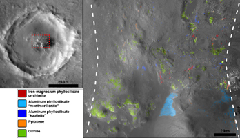
Figure 1
Click on the image for the larger versionStokes Crater, pictured here, is one of at least nine craters in the northern lowlands of Mars with exposures of hydrated minerals detected from orbit, according to a June 25, 2010, report.
These minerals, including phyllosilicates, have previously been found in thousands of small outcrops in the southern highlands of Mars, but had not previously been identified in the northern lowlands, which cover nearly half of the planet. The numerous outcrops in the south have been interpreted as evidence that early Mars -- about 4 billion years ago -- had wet conditions necessary for producing phyllosilicates and possibly conducive to life.
The exposures in some northern craters indicate these minerals are in an older layer underneath the younger surface of northern Mars and are made visible where crater-forming impacts have exposed the underlying material. The new report in the journal Science by John Carter of the University of Paris and his co-authors says that the northern finds suggest the ancient, wet conditions extended globally. Their report draws upon observations by the Compact Reconnaissance Imaging Spectrometer for Mars (CRISM) aboard NASA's Mars Reconnaissance Orbiter and the OMEGA spectrometer orbiting aboard the European Space Agency's Mars Express.
Stokes spans 66 kilometers (41 miles) in diameter, centered at 55.6 degrees north latitude, 171.2 degrees east longitude.
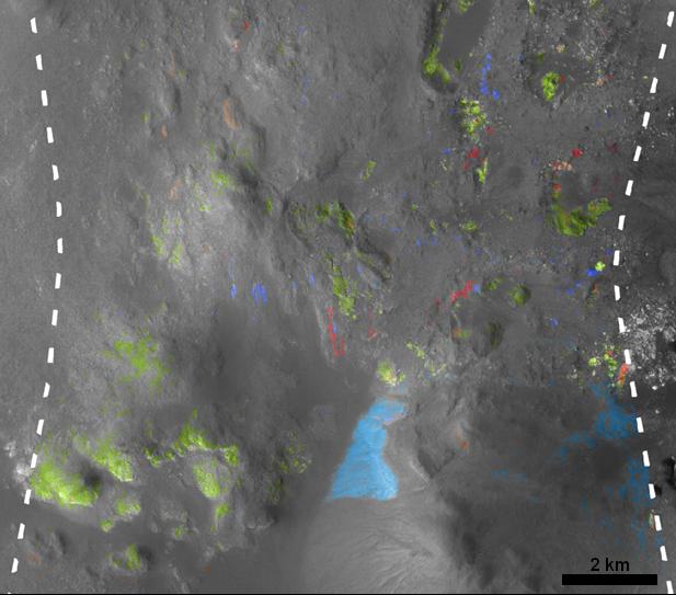
The image on the right (Figure 1) shows an area near the center of the crater, with color coding for where CRISM observations have shown exposures of three types of hydrated minerals and nearby exposures of two volcanic minerals unaltered by water: pyroxene and olivine. The scale bar is 2 kilometers (1.2 miles).
The context map on the left (Figure 1) indicates the location of that CRISM footprint within Stokes Crater. It is a mosaic of images taken by the Context Camera on Mars Reconnaissance Orbiter and the High Resolution Stereo Camera on Mars Express. The scale bar is 25 kilometers (15.5 miles).
NASA's Jet Propulsion Laboratory, a division of the California Institute of Technology, Pasadena, manages the Mars Reconnaissance Orbiter for the NASA Science Mission Directorate, Washington. Lockheed Martin Space Systems, Denver, built the spacecraft. The Johns Hopkins University Applied Physics Laboratory led the effort to build the CRISM instrument and operates CRISM in coordination with an international team of researchers from universities, government and the private sector. Malin Space Science Systems, San Diego, provided and operates the Context Camera.
The European Space Operations Centre in Darmstadt, Germany, operates the European Space Agency's Mars Express mission. The High Resolution Stereo Camera was developed by a group with leadership at the Freie Universitat Berlin.
