|
Your search criteria found 153 images Target is Venus |
| My List |
Addition Date | Target |
Mission
|
Instrument | Size |

|
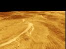
1996-03-14 | Venus |
Magellan |
Imaging Radar |
4000x3000x3 |
|
|||||
|
|
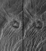
1996-03-14 | Venus |
Magellan |
Imaging Radar |
1860x2048x1 |
|
|||||
|
|
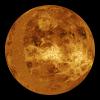
1996-09-23 | Venus |
Magellan |
Imaging Radar |
4096x4096x3 |
|
|||||
|
|
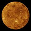
1996-07-18 | Venus |
Magellan |
Imaging Radar |
4096x4096x3 |
|
|||||
|
|
1996-07-19 | Venus |
Magellan |
Imaging Radar |
4096x5120x3 |
|
|||||
|
|
1998-06-04 | Venus |
Magellan |
Imaging Radar |
2000x940x3 |

|
|||||
|
|
1998-06-04 | Venus |
Magellan |
Imaging Radar |
2000x1600x3 |
|
|||||
|
|
1998-06-04 | Venus |
Magellan |
Imaging Radar |
1500x1500x3 |
|
|||||
|
|
1998-06-04 | Venus |
Magellan |
Imaging Radar |
1500x1500x3 |
|
|||||
|
|
1998-06-04 | Venus |
Magellan |
Imaging Radar |
2100x1500x3 |
|
|||||
|
|
1998-06-04 | Venus |
Magellan |
Imaging Radar |
2100x900x3 |
|
|||||
|
|
1998-06-04 | Venus |
Magellan |
Imaging Radar |
1500x1500x3 |
|
|||||
|
|
1998-06-04 | Venus |
Magellan |
Imaging Radar |
700x1400x3 |

|
|||||
|
|
1998-06-04 | Venus |
Magellan |
Imaging Radar |
700x1400x3 |
|
|||||
|
|
1998-06-04 | Venus |
Magellan |
Imaging Radar |
700x1400x3 |
|
|||||
|
|
1998-06-04 | Venus |
Magellan |
Imaging Radar |
700x1400x3 |
|
|||||
|
|
1996-09-26 | Venus |
Magellan |
Imaging Radar |
8192x7168x1 |
|
|||||
|
|
1996-09-26 | Venus |
Magellan |
Imaging Radar |
6940x5940x1 |
|
|||||
|
|
1996-09-26 | Venus |
Magellan |
Imaging Radar |
1024x1024x1 |
|
|||||
|
|
1996-09-26 | Venus |
Magellan |
Imaging Radar |
1620x1620x1 |
|
|||||
|
|
1996-09-26 | Venus |
Magellan |
Imaging Radar |
8180x7150x1 |
|
|||||
|
|
1996-09-26 | Venus |
Magellan |
Imaging Radar |
3640x2213x1 |
|
|||||
|
|
1996-09-26 | Venus |
Magellan |
Imaging Radar |
390x600x1 |
|
|||||
|
|
1996-10-23 | Venus |
Magellan |
Imaging Radar |
480x1022x1 |
|
|
|||||
|
|
1996-10-23 | Venus |
Magellan |
Imaging Radar |
730x1024x1 |
|
|||||
|
|
1996-10-23 | Venus |
Magellan |
Imaging Radar |
1737x818x1 |
|
|||||
|
|
1996-10-23 | Venus |
Magellan |
Imaging Radar |
1024x1024x1 |
|
|||||
|
|
1996-10-23 | Venus |
Magellan |
Imaging Radar |
2082x1736x1 |
|
|||||
|
|
1996-11-20 | Venus |
Magellan |
Imaging Radar |
975x1024x1 |
|
|||||
|
|
1996-11-20 | Venus |
Magellan |
Imaging Radar |
480x591x1 |
|
|||||
|
|
1996-11-20 | Venus |
Magellan |
Imaging Radar |
530x572x1 |
|
|||||
|
|
1996-11-20 | Venus |
Magellan |
Imaging Radar |
880x850x1 |
|
|||||
|
|
1996-11-22 | Venus |
Magellan |
Imaging Radar |
517x592x1 |
|
|||||
|
|
1996-11-26 | Venus |
Magellan |
Imaging Radar |
1633x1392x1 |

|
|||||
|
|
1996-11-26 | Venus |
Magellan |
Imaging Radar |
10240x10240x1 |
|
|||||
|
|
1996-11-26 | Venus |
Magellan |
Imaging Radar |
2500x2950x1 |
|
|||||
|
|
1996-11-26 | Venus |
Magellan |
Imaging Radar |
5475x5341x1 |
|
|||||
|
|
1996-12-02 | Venus |
Magellan |
Imaging Radar |
5000x4000x3 |
|
|||||
|
|
1996-11-07 | Venus |
Magellan |
Imaging Radar |
1000x1000x1 |
|
|||||
|
|
1996-11-14 | Venus |
Magellan |
Imaging Radar |
2560x1024x1 |
|
|||||
|
|
1996-11-14 | Venus |
Magellan |
Imaging Radar |
1880x1504x1 |

|
|||||
|
|
1996-11-14 | Venus |
Magellan |
Imaging Radar |
2510x3072x1 |
|
|||||
|
|
1996-11-14 | Venus |
Magellan |
Imaging Radar |
1126x1015x1 |
|
|||||
|
|
2001-03-15 | Venus |
Magellan |
Arecibo Radar Data Radar System |
13966x8887x3 |
|
|||||
|
|
2001-08-27 | Venus |
Magellan |
Arecibo Radar Data Radar System |
15464x9249x3 |
|
|||||
|
|
2010-04-08 | Venus |
Magellan Venus Express |
VIRTIS |
1920x1080x3 |
|
|||||
|
|
2020-06-08 | Venus |
Mariner |
2245x1096x3 | |
|
|||||
|
|
2003-06-27 | Venus |
Mariner 2 |
1515x1218x3 | |
|
|||||
|
|
2007-06-05 | Venus |
MESSENGER |
MDIS - Wide Angle |
608x919x1 |

|
|||||
|
|
2006-11-24 | Venus |
MESSENGER |
MDIS - Wide Angle |
1048x528x1 |

|
|||||
|
|
2007-06-05 | Venus |
MESSENGER |
MDIS - Wide Angle |
1024x1024x1 |
|
|||||
|
|
2010-02-02 | Venus |
MESSENGER |
MDIS - Wide Angle |
1024x1024x1 |
|
|||||
|
|
1998-06-03 | Venus |
Pioneer Venus |
Imaging Radar |
500x568x3 |
|
|||||

|
 |
 |
|
| 1-100 | 101-200 |
| Currently displaying images: 101 - 153 of 153 |