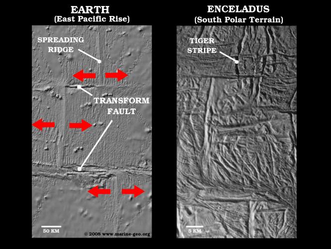
These two side-by-side images compare a characteristic sea-floor spreading feature on Earth, known as a spreading ridge transform, to a very similar looking arrangement of "tiger stripe" rift segments in the south polar terrain region of Saturn's moon Enceladus.
The left image shows a shaded relief map of bathymetry (or sonar-like topography) data covering a fast-spreading ridge along the Earth's East Pacific Rise at 9.5 degrees north latitude, 104 degrees west longitude. Spreading ridges are laterally offset in a characteristic "zig-zag" pattern that closely matches the offset pattern seen on the Enceladus tiger stripe rifts. Striations parallel to the seafloor ridges are produced symmetrically when upwelling magma in the rifts solidify and become welded on each side of the central trench.
In contrast, the transform-like structure on Enceladus (in the image on the right) is flanked by a very complicated arrangement of old fractures. If the Enceladus feature is indeed a type of transform, it indicates spreading in a way that significantly differs from sea-floor spreading: Either the Enceladus feature is not spreading symmetrically from the center of the tiger stripe rifts as usually occurs in terrestrial sea-floor spreading centers, or else the original indicators of symmetrical spreading have been erased by a complicated superposed fracture history.
The Enceladus data were acquired by NASA's Cassini spacecraft's imaging science sub-system during four close-targeted flybys of Enceladus in March, August and October 2008.
The Cassini-Huygens mission is a cooperative project of NASA, the European Space Agency and the Italian Space Agency. The Jet Propulsion Laboratory, a division of the California Institute of Technology in Pasadena, manages the mission for NASA's Science Mission Directorate, Washington, D.C. The Cassini orbiter and its two onboard cameras were designed, developed and assembled at JPL. The imaging operations center is based at the Space Science Institute in Boulder, Colo.
For more information about the Cassini-Huygens mission visit http://saturn.jpl.nasa.gov/. The Cassini imaging team homepage is at http://ciclops.org.
Sea-floor bathymetry data ©2008 MGDS; www.marine-geo.org from Carbotte, S.M., R. Arko, D.N. Chayes, W. Haxby, K. Lehnert, S. O'Hara, W.B.F. Ryan, R.A. Weissel, T. Shipley, L. Gahagan, K. Johnson, T. Shank (2004), New Integrated Data Management System for Ridge2000 and MARGINS Research, Eos Trans. AGU, 85(51), 553, DOI: 10.1029/2004EO510002.]
 Planetary Data System


