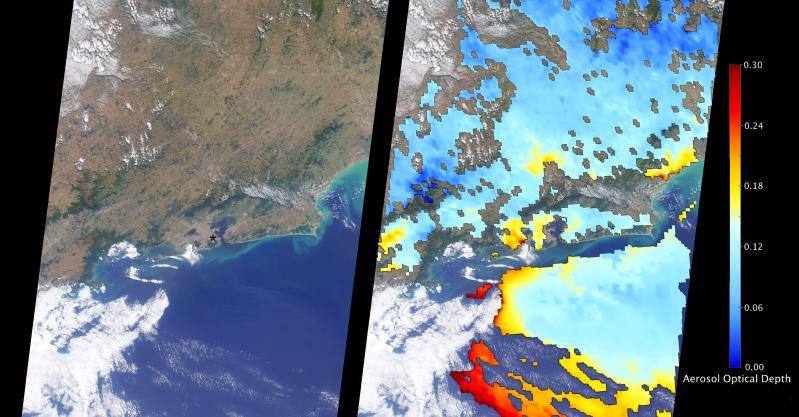
The Multi-angle Imaging SpectroRadiometer (MISR) instrument aboard NASA's Terra satellite passed directly over Rio de Janeiro, Brazil, on Aug. 2, 2016, just prior to the opening of the Summer Olympic Games. On the left is an image from MISR's nadir (downward-looking) camera; the width of the image is 235 miles (378 kilometers), and Rio de Janeiro is visible as the large gray area on the coast in the center. The black asterisk marks the location of the Maracanã Stadium in downtown, where the opening ceremonies were held.
In the weeks leading up to the Aug. 5 opening ceremonies in Rio de Janeiro, there have been reports of elevated levels of particulate matter in the region. Particulate matter refers to tiny airborne droplets or pieces of soot and dust that can end up in the lungs, comprising an all-too-common problem for many cities around the world.
MISR data are routinely used to estimate the amount of air pollution via measurements of aerosol optical depth, which is a measure of how much incoming light from the sun is blocked by particles in the atmosphere. On the right, a map of aerosol optical depth is superimposed on the image. Individual squares making up this map measure 2.7 miles (4.4 kilometers) on a side, and holes in the map occur where an aerosol amount could not be determined, such as where clouds are present. Optical depth over Rio is slightly elevated compared to its surroundings, most likely due to the presence of air pollution, with values from 0.15-0.25. For reference, an optical depth of 0.2 corresponds to light haze.
The product shown here is a prototype of a new version of the MISR aerosol product to be publicly released in the near future, and increases the spatial resolution of the aerosol information by a factor of 16 compared to the currently available product, making it possible to observe the fine details of optical depth over urban areas.
These data were captured during Terra orbit 88426. MISR was built and is managed by NASA's Jet Propulsion Laboratory, Pasadena, California, for NASA's Science Mission Directorate, Washington, D.C. The Terra spacecraft is managed by NASA's Goddard Space Flight Center, Greenbelt, Maryland. The MISR data were obtained from the NASA Langley Research Center Atmospheric Science Data Center, Hampton, Virginia. JPL is a division of the California Institute of Technology in Pasadena.
 Planetary Data System


