Launched Sept. 21, 2014, to the International Space Station, NASA's newest Earth-observing mission, the International Space Station-RapidScat scatterometer to measure global ocean near-surface wind speeds and directions, has returned its first preliminary images.
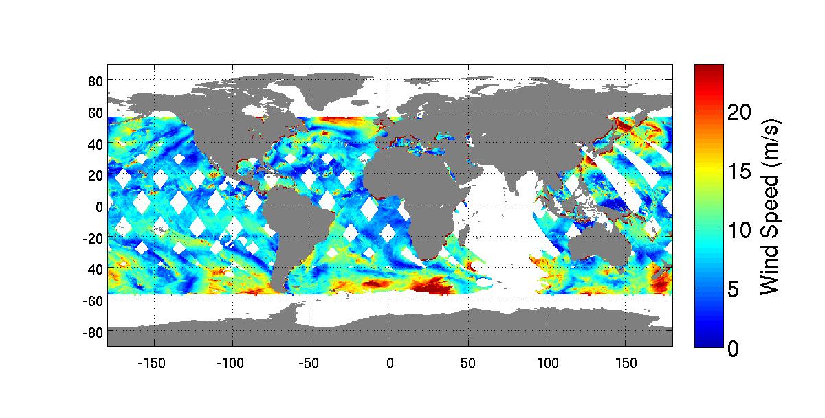
Following activation of the instrument on Oct. 1, mission scientists created this composite image of global ocean vector wind (OVW) speeds for the first day of data collection. Higher wind speeds are shown in reds and yellows, with blue colors depicting lower wind speeds. One meter per second equals approximately 2.24 miles per hour.
This first map of RapidScat's wind speed collection pattern used real-time data only and therefore did not include some data over the Indian Ocean that weren't available at the time of its generation. The map is representative, however, of the typical coverage that ISS-RapidScat will deliver on a near-real-time basis to operational weather forecasting agencies around the world. From its perch on the space station, RapidScat will be able to map ocean winds between 57 degrees north and south of the equator. Full global coverage within those latitudes is obtained every 48 hours. The data will be distributed publically to the science community via NASA's Physical Oceanography Distributed Active Archive Center (PODAAC).
Although the instrument is not yet fully calibrated, a preliminary validation of the accuracy of the data shows that RapidScat is already near its science performance goals at activation.
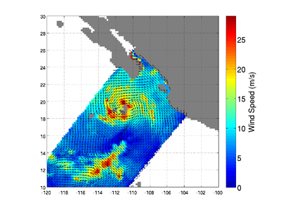
The second figure shows Tropical Storm Simon as seen by RapidScat as it approached Mexico's Baja California peninsula at 0210 UTC Time Oct. 4 (7:10 p.m. PDT Oct. 3). The tropical storm is easily identified by its high winds and closed circulation pattern. Wind speeds are shown in color, with reds and yellows being highest, while wind directions are shown as arrows. One meter per second equals approximately 2.24 miles per hour. RapidScat, like its predecessor, NASA's QuikScat, will provide images like this on a near-real-time basis to operational agencies like NOAA's National Hurricane Center, where forecasters will use them to improve hurricane and storm warnings and forecasts. Simon is expected to make landfall in Mexico as a tropical depression on Oct. 8. (http://www.nhc.noaa.gov/refresh/graphics_ep4+shtml/204322.shtml?5-daynl.

