PDS logoPlanetary Data System
PDS Information
Find a Node - Use these links to navigate to any of the 8 publicly accessible PDS Nodes.

This bar indicates that you are within the PDS enterprise which includes 6 science discipline nodes and 2 support nodes which are overseen by the Project Management Office at NASA's Goddard Space Flight Center (GSFC). Each node is led by an expert in the subject discipline, supported by an advisory group of other practitioners of that discipline, and subject to selection and approval under a regular NASA Research Announcement.
Click here to return to the Photojournal Home Page Click here to view a list of Photojournal Image Galleries Photojournal_inner_header
Latest Images  |  Spacecraft & Technology  |  Animations  |  Space Images App  |  Feedback  |  Photojournal Search  

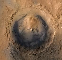
PIA15687: Destination Gale Crater in August 2012
 Target Name:  Mars
 Is a satellite of:  Sol (our sun)
 Mission:  Mars Science Laboratory (MSL)
 Spacecraft:  Curiosity
 Product Size:  1564 x 1528 pixels (w x h)
 Produced By:  JPL
 Full-Res TIFF:  PIA15687.tif (7.182 MB)
 Full-Res JPEG:  PIA15687.jpg (264.8 kB)

Click on the image above to download a moderately sized image in JPEG format (possibly reduced in size from original)

Original Caption Released with Image:

As of June 2012, the target landing area for NASA's Mars Science Laboratory mission is the ellipse marked on this image of Gale Crater. The ellipse is about 12 miles long and 4 miles wide (20 kilometers by 7 kilometers).

Landing will be about 10:31 p.m. on Aug. 5, 2012, Pacific Daylight (early Aug. 6 Universal Time and Eastern Time). If landing goes well, the mission's rover, Curiosity, will drive in subsequent months to science destinations on Mount Sharp, outside of the landing ellipse.

This view of Gale Crater is derived from a combination of data from three Mars orbiters. The view is looking straight down on the crater from orbit. Gale Crater is 96 miles (154 kilometers) in diameter. Mount Sharp rises about 3.4 miles (5.5 kilometers) above the floor of Gale Crater.

Stratification on Mount Sharp suggests the mountain is a surviving remnant of an extensive series of deposits that were laid down after a massive impact that excavated Gale Crater more than 3 billion years ago. The layers offer a history book of sequential chapters recording environmental conditions when each stratum was deposited.

During a prime mission lasting nearly two years after landing, Curiosity will use 10 instruments to investigate whether this area of Mars has ever offered conditions favorable for life, including the chemical ingredients for life.

The image combines elevation data from the High Resolution Stereo Camera on the European Space Agency's Mars Express orbiter, image data from the Context Camera on NASA's Mars Reconnaissance Orbiter, and color information from Viking Orbiter imagery.

NASA's Jet Propulsion Laboratory, a division of the California Institute of Technology, Pasadena, manages the Mars Science Laboratory mission for the NASA Science Mission Directorate, Washington.

Image Credit:
NASA/JPL-Caltech/ESA/DLR/FU Berlin/MSSS

Image Addition Date:
2012-06-11