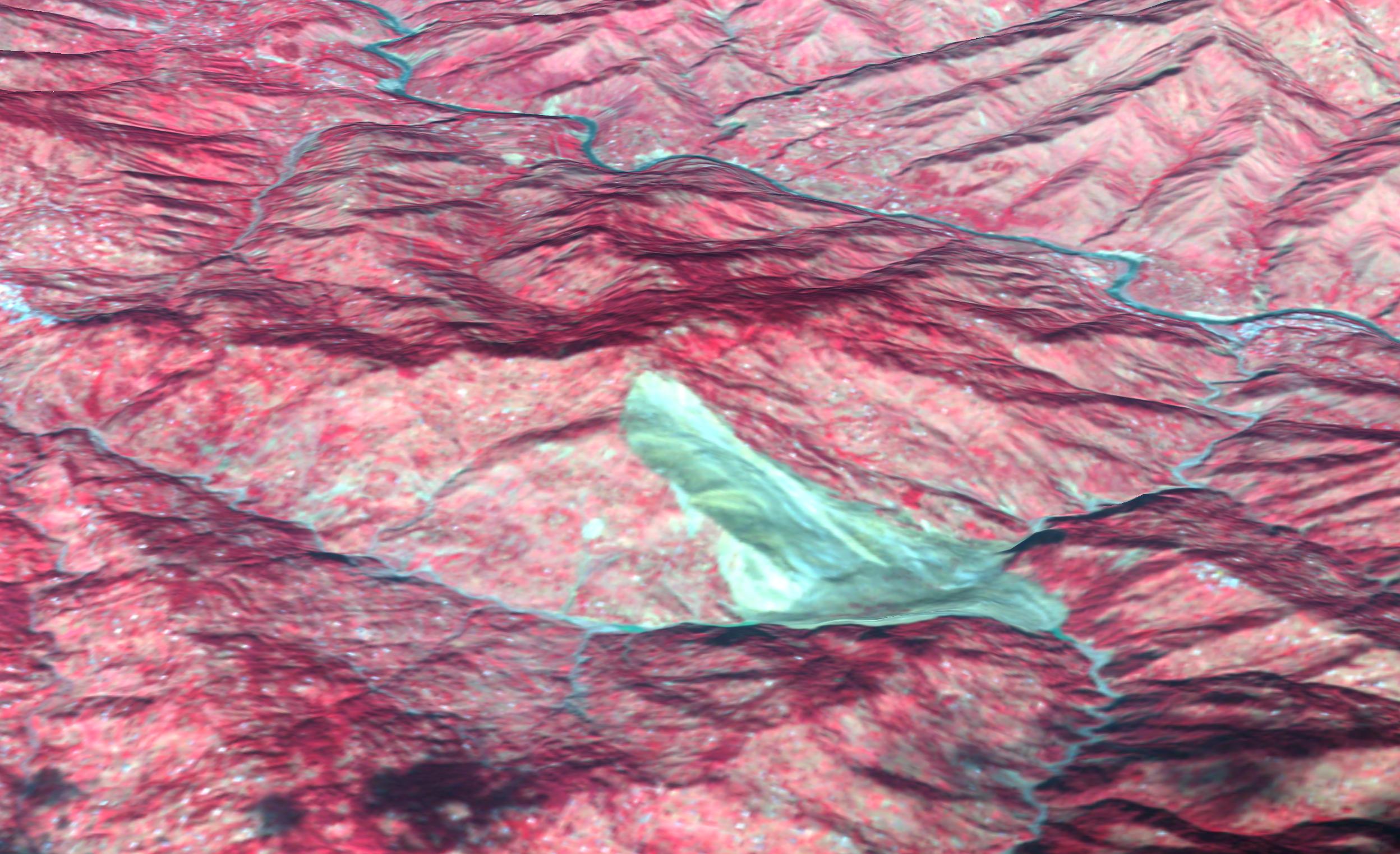
This 3D perspective view combines an image acquired by the Advanced Spaceborne Thermal Emission and Reflection Radiometer on NASA's Terra spacecraft on October 11, 2005 with digital topography from the Shuttle Radar Topography Mission. It depicts a large landslide in an area about 5 kilometers (3 miles) wide approximately 50 km southeast of the epicenter of the magnitude 7.6 Pakistan earthquake on October 8, 2005. The landslide (brownish gray color) slid down a mountain in the Pir Punjal (or Pir Panjal) range of Kashmir between Muzaffarabad and Uri, and has blocked two small rivers. Small lakes (dark blue color) have started to form behind the landslide. The center of the image is at about 34 degrees, 9 minutes North; 73 degrees, 43 minutes East. A number of smaller landslides are also visible as gray patches, mostly along the main river (Jhelum River) and other valleys. The red color is vegetation in this false-color image, and the view direction is from the southeast. For the map view image of this area see PIA03028.
ASTER is one of five Earth-observing instruments launched December 18, 1999, on NASA's Terra satellite. The instrument was built by Japan's Ministry of Economy, Trade and Industry. A joint U.S./Japan science team is responsible for validation and calibration of the instrument and the data products.
The broad spectral coverage and high spectral resolution of ASTER provides scientists in numerous disciplines with critical information for surface mapping, and monitoring of dynamic conditions and temporal change. Example applications are: monitoring glacial advances and retreats; monitoring potentially active volcanoes; identifying crop stress; determining cloud morphology and physical properties; wetlands evaluation; thermal pollution monitoring; coral reef degradation; surface temperature mapping of soils and geology; and measuring surface heat balance.
The U.S. science team is located at NASA's Jet Propulsion Laboratory, Pasadena, Calif. The Terra mission is part of NASA's Science Mission Directorate.
Size: Roughly 5 km (3 miles) across; scale varies in this perspective view
Location: 34.149 deg. North latitude, 73.712 deg. East longitude
Orientation: View from southeast towards the northwest
Vertical Exaggeration: 1
Image Data: ASTER bands 1, 2, and 3
Topography Data: SRTM
Original Data Resolution: 15 m ASTER, 3-arcseconds (90 m) SRTM
Date Acquired: ASTER: October 11, 2005, SRTM February 2000
