PDS logoPlanetary Data System
PDS Information
Find a Node - Use these links to navigate to any of the 8 publicly accessible PDS Nodes.

This bar indicates that you are within the PDS enterprise which includes 6 science discipline nodes and 2 support nodes which are overseen by the Project Management Office at NASA's Goddard Space Flight Center (GSFC). Each node is led by an expert in the subject discipline, supported by an advisory group of other practitioners of that discipline, and subject to selection and approval under a regular NASA Research Announcement.
Click here to return to the Photojournal Home Page Click here to view a list of Photojournal Image Galleries Photojournal_inner_header
Latest Images  |  Spacecraft & Technology  |  Animations  |  Space Images App  |  Feedback  |  Photojournal Search  

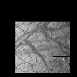
PIA00518: Ridges on Europa
 Target Name:  Europa
 Is a satellite of:  Jupiter
 Mission:  Galileo
 Spacecraft:  Galileo Orbiter
 Instrument:  Solid-State Imaging 
 Product Size:  800 x 800 pixels (w x h)
 Produced By:  JPL
 Producer ID:  P48127 MRPS77846
 Addition Date:  1997-12-18
 Primary Data Set:  Galileo EDRs
 Full-Res TIFF:  PIA00518.tif (340.1 kB)
 Full-Res JPEG:  PIA00518.jpg (84.9 kB)

Click on the image above to download a moderately sized image in JPEG format (possibly reduced in size from original)

Original Caption Released with Image:

This view of Jupiter's moon Europa shows a portion of the surface that has been highly disrupted by fractures and ridges. This picture covers an area about 238 kilometers (150 miles) wide by 225 kilometers (140 miles), or about the distance between Los Angeles and San Diego. Symmetric ridges in the dark bands suggest that the surface crust was separated and filled with darker material, somewhat analogous to spreading centers in the ocean basins of Earth. Although some impact craters are visible, their general absence indicates a youthful surface. The youngest ridges, such as the two features that cross the center of the picture, have central fractures, aligned knobs, and irregular dark patches. These and other features could indicate cryovolcanism, or processes related to eruption of ice and gases.

This picture, centered at 16 degrees south latitude, 196 degrees west longitude, was taken at a distance of 40,973 kilometers (25,290 mi) on November 6, 1996 by the Galileo spacecraft solid state imaging television camera onboard the Galileo spacecraft during its third orbit around Jupiter.

The Galileo mission is managed by the Jet Propulsion Laboratory for NASA's Office of Space Science, Washington, D.C.

This image and other images and data received from Galileo are posted on the Galileo mission home page on the World Wide Web at http://galileo.jpl.nasa.gov. Background information and educational context for the images can be found at http://www.jpl.nasa.gov/galileo/sepo.

Image Credit:
NASA/JPL

Image Addition Date:
1997-12-18