PDS logoPlanetary Data System
PDS Information
Find a Node - Use these links to navigate to any of the 8 publicly accessible PDS Nodes.

This bar indicates that you are within the PDS enterprise which includes 6 science discipline nodes and 2 support nodes which are overseen by the Project Management Office at NASA's Goddard Space Flight Center (GSFC). Each node is led by an expert in the subject discipline, supported by an advisory group of other practitioners of that discipline, and subject to selection and approval under a regular NASA Research Announcement.
Click here to return to the Photojournal Home Page Click here to view a list of Photojournal Image Galleries Photojournal_inner_header
Latest Images  |  Spacecraft & Technology  |  Animations  |  Space Images App  |  Feedback  |  Photojournal Search  

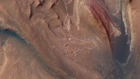
PIA26017: A Map of Curiosity's Difficult Climb
 Target Name:  Mars
 Is a satellite of:  Sol (our sun)
 Mission:  Mars Reconnaissance Orbiter (MRO)
 Spacecraft:  Mars Reconnaissance Orbiter (MRO)
 Instrument:  HiRISE
 Product Size:  3840 x 2160 pixels (w x h)
 Produced By:  University of Arizona
 Full-Res TIFF:  PIA26017.tif (24.89 MB)
 Full-Res JPEG:  PIA26017.jpg (2.072 MB)

Click on the image above to download a moderately sized image in JPEG format (possibly reduced in size from original)

Original Caption Released with Image:

This map shows the route NASA's Curiosity Mars rover took from May into July 2023 to complete the most difficult climb of the mission. Starting in "Marker Band Valley" (the darker area at the top center), the route shows white dots for each stop the rover made. As it struggled to crest a 23-degree slope covered with slippery sand and wheel-size rocks, the rover experienced a number of faults that stopped it mid-drive. That area can be seen just below the center of the image, where a cluster of the white dots bunch up.

Rover drivers ultimately decided to veer off 492 feet (150 meters), approaching part of the slope with an incline below 15 degrees and less sand and fewer rocks (the part of the route farthest to the right). Curiosity was able to crest the slope there, then drove back to view a cluster of impact craters (the pockmarked terrain towards the bottom of the image).

Curiosity is now heading further up Mount Sharp, the 3-mile-tall (5-kilometer-tall) mountain it has been climbing since 2014.

Curiosity was built by NASA's Jet Propulsion Laboratory, which is managed by Caltech in Pasadena, California. JPL leads the mission on behalf of NASA's Science Mission Directorate in Washington.

The map relies on imagery from the High-Resolution Imaging Science Experiment (HiRISE camera) aboard NASA's Mars Reconnaissance Orbiter.

The University of Arizona, in Tucson, operates HiRISE, which was built by Ball Aerospace & Technologies Corp., in Boulder, Colorado. MRO was built by Lockheed Martin Space. JPL manages the Mars Reconnaissance Orbiter Project for NASA's Science Mission Directorate.

For more about Curiosity, visit: http://mars.nasa.gov/msl

For more about MRO, visit: http://mars.nasa.gov/mro

Image Credit:
NASA/JPL-Caltech/USGS-Flagstaff/University of Arizona

Image Addition Date:
2023-08-03