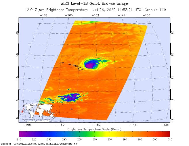
NASA's Atmospheric Infrared Sounder (AIRS) was monitoring Hurricane Douglas as it took aim at the Hawaiian Islands on July 26. Perched on NASA's Aqua satellite, AIRS is an instrument that studies Earth's weather and climate.
As of 11 a.m. local time, Douglas was sweeping toward Hawaii with the potential to directly hit portions of the islands, from Maui to Kauai, in the late afternoon or evening. The purple areas in the AIRS image — taken at 1:53 a.m. local time on July 26 — indicate very cold clouds high in the atmosphere generally linked to heavy rainfall. Warmer clouds closer to Earth's surface show up as green and blue, and orange areas indicate cloud-free parts of the sky.
The Category 1 hurricane was packing maximum sustained winds of 85 mph (140 kph) on the morning of July 26. Douglas' storm surge is forecast to push water levels as high as 3 feet (0.9 meters) above normal tides. The storm could dump as much as 15 inches (38 centimeters) of rain onto isolated parts of the Hawaiian Islands.
AIRS, in conjunction with the Advanced Microwave Sounding Unit (AMSU), senses emitted infrared and microwave radiation from Earth to provide a three-dimensional look at Earth's weather and climate. Working in tandem, the two instruments make simultaneous observations down to Earth's surface. With more than 2,000 channels sensing different regions of the atmosphere, the system creates a global, three-dimensional map of atmospheric temperature and humidity, cloud amounts and heights, greenhouse gas concentrations and many other atmospheric phenomena. Launched into Earth orbit in 2002, the AIRS and AMSU instruments fly aboard NASA's Aqua spacecraft and are managed by NASA's Jet Propulsion Laboratory in Southern California, under contract to NASA. JPL is a division of Caltech.
More information about AIRS can be found at https://airs.jpl.nasa.gov.