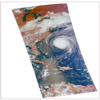
Figure 1
Click on image for larger version
This image, taken at 1:35 pm local time on Tuesday, September 11, 2018 by the Atmospheric Infrared Sounder (AIRS) onboard NASA's Aqua satellite shows Hurricane Florence whose strong winds are expected to reach the Carolina coast late Thursday. Florence intensified from a Category 2 to a Category 4 storm in a matter of hours. As of Tuesday evening, Florence had maximum sustained winds of 140 mph (225 kph).
Figure 1 shows Hurricane Florence in visible light, much as our eyes would see it. This is a classic image of a strong hurricane, with a well-defined eye near the center of a large, thick cloud shield containing bands of very thick clouds, and high, thin clouds far from the storm where air flows away from the thick rain clouds.
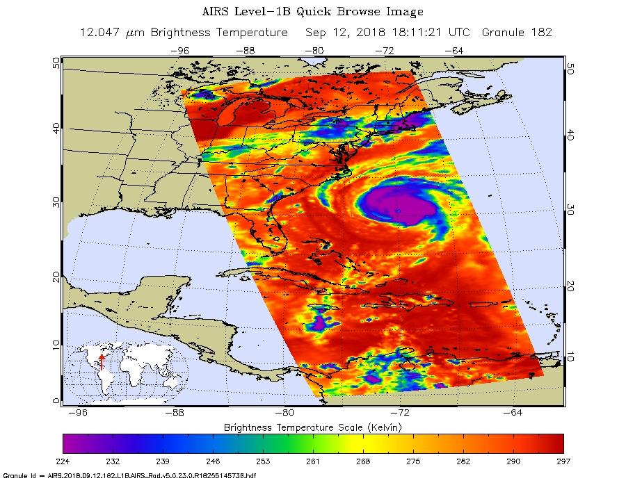
AIRS has more than 2,000 "channels" that capture various hues of infrared, and this image represents the temperature of the cloud tops and the ocean surface (called "brightness temperature" in the image). Purple shows very cold clouds high in the atmosphere, blue and green show the warmer temperatures of lower clouds, and red shows the surface. Florence has the characteristics of a mature, powerful hurricane: an extensive, nearly symmetric ring of deep, cold rain clouds in purple; slightly shallower rain clouds in the outer perimeter seen in green; a large area of cloud-free air flowing away from the storm in red; and a well-defined eye (seen as the greenish spot near the center) where warm low clouds can be seen below.
AIRS, in conjunction with the Advanced Microwave Sounding Unit, AMSU, senses emitted infrared and microwave radiation from Earth to provide a three-dimensional look at Earth's weather and climate. Working in tandem, the two instruments make simultaneous observations down to Earth's surface, even in the presence of heavy clouds. With more than 2,000 channels sensing different regions of the atmosphere, the system creates a global, three-dimensional map of atmospheric temperature and humidity, cloud amounts and heights, greenhouse gas concentrations, and many other atmospheric phenomena. Launched into Earth orbit in 2002, the AIRS and AMSU instruments fly onboard NASA's Aqua spacecraft and are managed by NASA's Jet Propulsion Laboratory in Pasadena, California, under contract to NASA. JPL is a division of the California Institute of Technology in Pasadena.
More information about AIRS can be found at https://airs.jpl.nasa.gov.

