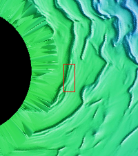
Context image This VIS image shows 'streamers' of clouds created by katabatic winds at the north polar cap. Katabatic winds are created by cold air sinking at the pole and then speeding along the ice surface towards the edge of the polar cap. When the winds enter troughs the wind regime changes from laminar flow to choatic and clouds of ice particles and/or dust are visible. This wind activity peaks at the start of northern hemisphere summer.
Orbit Number: 53942 Latitude: 86.8433 Longitude: 99.3149 Instrument: VIS Captured: 2014-02-10 10:50
Please see the THEMIS Data Citation Note for details on crediting THEMIS images.
NASA's Jet Propulsion Laboratory manages the 2001 Mars Odyssey mission for NASA's Science Mission Directorate, Washington, D.C. The Thermal Emission Imaging System (THEMIS) was developed by Arizona State University, Tempe, in collaboration with Raytheon Santa Barbara Remote Sensing. The THEMIS investigation is led by Dr. Philip Christensen at Arizona State University. Lockheed Martin Astronautics, Denver, is the prime contractor for the Odyssey project, and developed and built the orbiter. Mission operations are conducted jointly from Lockheed Martin and from JPL, a division of the California Institute of Technology in Pasadena.