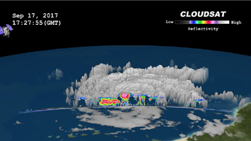
Click on the image for larger animationNASA's CloudSat satellite flew over Hurricane Maria on Sept. 17, 2017, at 1:23 p.m. EDT (17:23 UTC) as the storm had just strengthened into a hurricane in the Atlantic Ocean. Hurricane Maria contained estimated maximum sustained winds of 75 miles per hour (65 knots) and had a minimum barometric pressure of 986 millibars.
CloudSat flew over Maria through the center of the rapidly intensifying storm, directly through an overshooting cloud top (a dome-shaped protrusion that shoots out of the top of the anvil cloud of a thunderstorm). CloudSat reveals the vertical extent of the overshooting cloud top, showing the estimated height of the cloud to be 11 miles (18 kilometers). Areas of high reflectivity with deep red and pink colors extend well above 9 miles (15 kilometers) in height, showing large amounts of water being drawn upward high into the atmosphere.
CloudSat is a satellite mission designed to measure the vertical structure of clouds from space. The radar data produces detailed images of cloud structures which will contribute to a better understanding of clouds and climate. Quicklook Images can viewed at the CloudSat Data Processing Center.