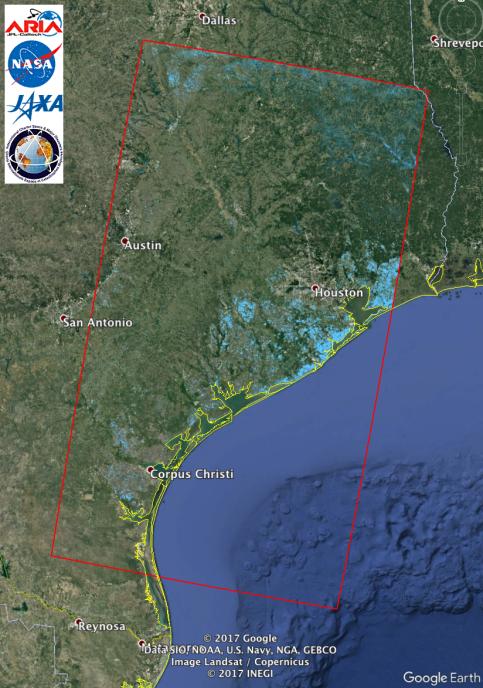
The Advanced Rapid Imaging and Analysis (ARIA) team at NASA's Jet Propulsion Laboratory in Pasadena, California, used synthetic aperture radar imagery from the Japan Aerospace Exploration Agency's (JAXA) ALOS-2 satellite to create this Flood Proxy Map depicting areas of Southeastern Texas that are likely flooded as a result of Hurricane Harvey (shown by light blue pixels). The map is derived images taken before (July 30, 2017) and after (Aug. 27, 2017) Hurricane Harvey made landfall. The map covers an area of 220 by 400 miles (350 by 640 kilometers). Each pixel measures about 55 yards (50 meters) across. Local ground observations provided anecdotal preliminary validation. The results are also cross-validated with ARIA Sentinel-1 flood proxy map v0.2. The map should be used as guidance, and may be less reliable over urban areas. ALOS-2 data were accessed through the International Charter.
In this update to the image in PIA21928, the ARIA team analyzed the previously acquired ALOS-2 synthetic aperture radar data together with new SAR data from Sentinel-1 acquired on Aug. 29 and adjusted the thresholds of the flood proxy maps from the two data sets to achieve consistency. While the ALOS-2 SAR data were acquired on Aug. 27 and the Sentinel-1 data were acquired on Aug. 29, the areas detected as flooded should not be radically different.
For more information about ARIA, visit http://aria.jpl.nasa.gov.