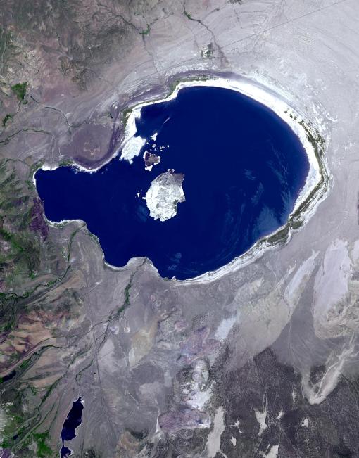
In eastern California, along the western edge of the Great Basin, sits Mono Lake. This is a salty remnant of a wetter era. Estimates are that the lake existed for at least 760,000 years. Now surrounded by mountain ranges, however, Mono Lake has no outlet; water entering the lake can only evaporate away, so Mono Lake is saltier than the ocean. South of the lake appear some of the geologic features known as Mono Craters. Geologists estimate that the Mono Craters last erupted about 650 years ago. The image was acquired July 7, 2016, covers an area of 22.6 by 34 km, and is located at 37.9 degrees north, 119 degrees west.
With its 14 spectral bands from the visible to the thermal infrared wavelength region and its high spatial resolution of 15 to 90 meters (about 50 to 300 feet), ASTER images Earth to map and monitor the changing surface of our planet. ASTER is one of five Earth-observing instruments launched Dec. 18, 1999, on Terra. The instrument was built by Japan's Ministry of Economy, Trade and Industry. A joint U.S./Japan science team is responsible for validation and calibration of the instrument and data products.
The broad spectral coverage and high spectral resolution of ASTER provides scientists in numerous disciplines with critical information for surface mapping and monitoring of dynamic conditions and temporal change. Example applications are: monitoring glacial advances and retreats; monitoring potentially active volcanoes; identifying crop stress; determining cloud morphology and physical properties; wetlands evaluation; thermal pollution monitoring; coral reef degradation; surface temperature mapping of soils and geology; and measuring surface heat balance.
The U.S. science team is located at NASA's Jet Propulsion Laboratory, Pasadena, Calif. The Terra mission is part of NASA's Science Mission Directorate, Washington, D.C.
More information about ASTER is available at http://asterweb.jpl.nasa.gov/.