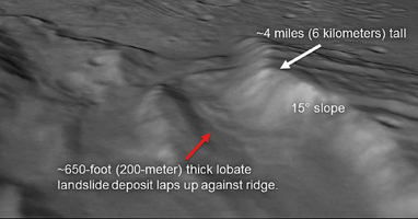
Annotated Figure
Click on the image for larger versionScientists from NASA's New Horizons mission have spotted signs of long run-out landslides on Pluto's largest moon, Charon. This perspective view of Charon's informally named "Serenity Chasm" consists of topography generated from stereo reconstruction of images taken by New Horizons' Long Range Reconnaissance Imager (LORRI) and Multispectral Visible Imaging Camera (MVIC), supplemented by a "shape-from-shading" algorithm.
The topography is then overlain with the PIA21128 image mosaic and the perspective view is rendered. The MVIC image was taken from a distance of 45,458 miles (73,159 kilometers) while the LORRI picture was taken from 19,511 miles (31,401 kilometers) away, both on July 14, 2015.
The Johns Hopkins University Applied Physics Laboratory in Laurel, Maryland, designed, built, and operates the New Horizons spacecraft, and manages the mission for NASA's Science Mission Directorate. The Southwest Research Institute, based in San Antonio, leads the science team, payload operations and encounter science planning. New Horizons is part of the New Frontiers Program managed by NASA's Marshall Space Flight Center in Huntsville, Alabama.
