PDS logoPlanetary Data System
PDS Information
Find a Node - Use these links to navigate to any of the 8 publicly accessible PDS Nodes.

This bar indicates that you are within the PDS enterprise which includes 6 science discipline nodes and 2 support nodes which are overseen by the Project Management Office at NASA's Goddard Space Flight Center (GSFC). Each node is led by an expert in the subject discipline, supported by an advisory group of other practitioners of that discipline, and subject to selection and approval under a regular NASA Research Announcement.
Click here to return to the Photojournal Home Page Click here to view a list of Photojournal Image Galleries Photojournal_inner_header
Latest Images  |  Spacecraft & Technology  |  Animations  |  Space Images App  |  Feedback  |  Photojournal Search  

PIA20959: Dawn LAMO Image 197
 Target Name:  Ceres
 Is a satellite of:  Sol (our sun)
 Mission:  Dawn
 Spacecraft:  Dawn
 Instrument:  Framing Camera
 Product Size:  1024 x 1024 pixels (w x h)
 Produced By:  JPL
 Full-Res TIFF:  PIA20959.tif (1.05 MB)
 Full-Res JPEG:  PIA20959.jpg (226.3 kB)

Click on the image above to download a moderately sized image in JPEG format (possibly reduced in size from original)

Updated Caption: (View Original Caption)

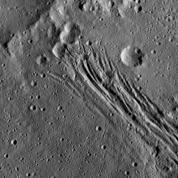
This image, taken by NASA's Dawn spacecraft, shows a series of linear features, which are depressions that located within the large Yalode Crater on Ceres. The Dawn team has named this collection of grooves Nar Sulcus. A "sulcus" is terrain with long, parallel fractures. The widest of the linear features is approximately 0.9 miles (1.5 kilometers) in width.

Scientists think these features formed when extensional stresses pulled the surface of Ceres apart. In the upper part of the image, the linear features cut through several impact craters, indicating that the fractures are younger than those particular craters.

The linear features are not the youngest things visible in this view, however. There are also small impact craters imprinted upon them, meaning those craters must have appeared more recently.

Yalode is 160 miles (260 kilometers) in diameter.

Dawn took this image on June 15, 2016, from its low-altitude mapping orbit, at a distance of about 240 miles (385 kilometers) above the surface. The image resolution is 120 feet (35 meters) per pixel.

Dawn's mission is managed by JPL for NASA's Science Mission Directorate in Washington. Dawn is a project of the directorate's Discovery Program, managed by NASA's Marshall Space Flight Center in Huntsville, Alabama. UCLA is responsible for overall Dawn mission science. Orbital ATK, Inc., in Dulles, Virginia, designed and built the spacecraft. The German Aerospace Center, the Max Planck Institute for Solar System Research, the Italian Space Agency and the Italian National Astrophysical Institute are international partners on the mission team. For a complete list of mission participants, see http://dawn.jpl.nasa.gov/mission.

For more information about the Dawn mission, visit http://dawn.jpl.nasa.gov.

Image Credit:
NASA/JPL-Caltech/UCLA/MPS/DLR/IDA

Image Addition Date:
2016-10-20