PDS logoPlanetary Data System
PDS Information
Find a Node - Use these links to navigate to any of the 8 publicly accessible PDS Nodes.

This bar indicates that you are within the PDS enterprise which includes 6 science discipline nodes and 2 support nodes which are overseen by the Project Management Office at NASA's Goddard Space Flight Center (GSFC). Each node is led by an expert in the subject discipline, supported by an advisory group of other practitioners of that discipline, and subject to selection and approval under a regular NASA Research Announcement.
Click here to return to the Photojournal Home Page Click here to view a list of Photojournal Image Galleries Photojournal_inner_header
Latest Images  |  Spacecraft & Technology  |  Animations  |  Space Images App  |  Feedback  |  Photojournal Search  

PIA20716: A First: NASA Spots Single Methane Leak from Space
 Target Name:  Earth
 Is a satellite of:  Sol (our sun)
 Mission:  Earth Observing System (EOS)
 Spacecraft:  ER-2
Earth Observing-1 (EO-1)
 Instrument:  AVIRIS
Hyperion Hyperspectral Imager
 Product Size:  1600 x 900 pixels (w x h)
 Produced By:  Goddard Space Flight Center
 Full-Res TIFF:  PIA20716.tif (4.049 MB)
 Full-Res JPEG:  PIA20716.jpg (236.9 kB)

Click on the image above to download a moderately sized image in JPEG format (possibly reduced in size from original)

Original Caption Released with Image:

Click here for larger version of PIA20716
Click on the image for larger version

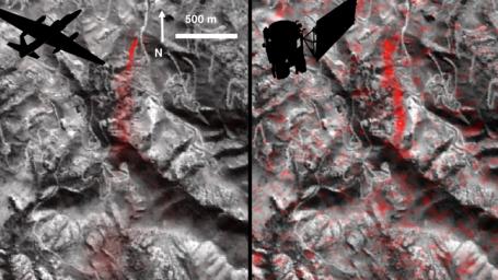
Atmospheric methane is a potent greenhouse gas, but the percentage of it produced through human activities is still poorly understood. Future instruments on orbiting satellites can help address this issue by surveying human-produced methane emissions. Recent data from the Aliso Canyon event, a large accidental methane release near Porter Ranch, California, demonstrates this capability. The Hyperion imaging spectrometer onboard NASA's EO-1 satellite successfully detected this release event on three different overpasses during the winter of 2015-2016. This is the first time the methane plume from a single facility has been observed from space. The orbital observations were consistent with airborne measurements.

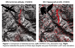
This image pair shows a comparison of detected methane plumes over Aliso Canyon, California, acquired 11 days apart in Jan. 2016 by: (left) NASA's AVIRIS instrument on a NASA ER-2 aircraft at 4.1 miles (6.6 kilometers) altitude and (right) by the Hyperion instrument on NASA's Earth Observing-1 satellite in low-Earth orbit. The additional red streaks visible in the EO-1 Hyperion image result from measurement noise -- Hyperion was not specifically designed for methane sensing and is not as sensitive as AVIRIS. Additionally, the EO-1 satellite's current orbit provided poor illumination conditions. Future instruments with much greater sensitivity on orbiting satellites can survey the biggest sources of human-produced methane around the world.

For more information on EO-1, visit http://science.nasa.gov/missions/eo-1/

For more information on AVIRIS, visit http://aviris.jpl.nasa.gov/.

Image Credit:
NASA/JPL-Caltech/Caltech/GSFC

Image Addition Date:
2016-06-14