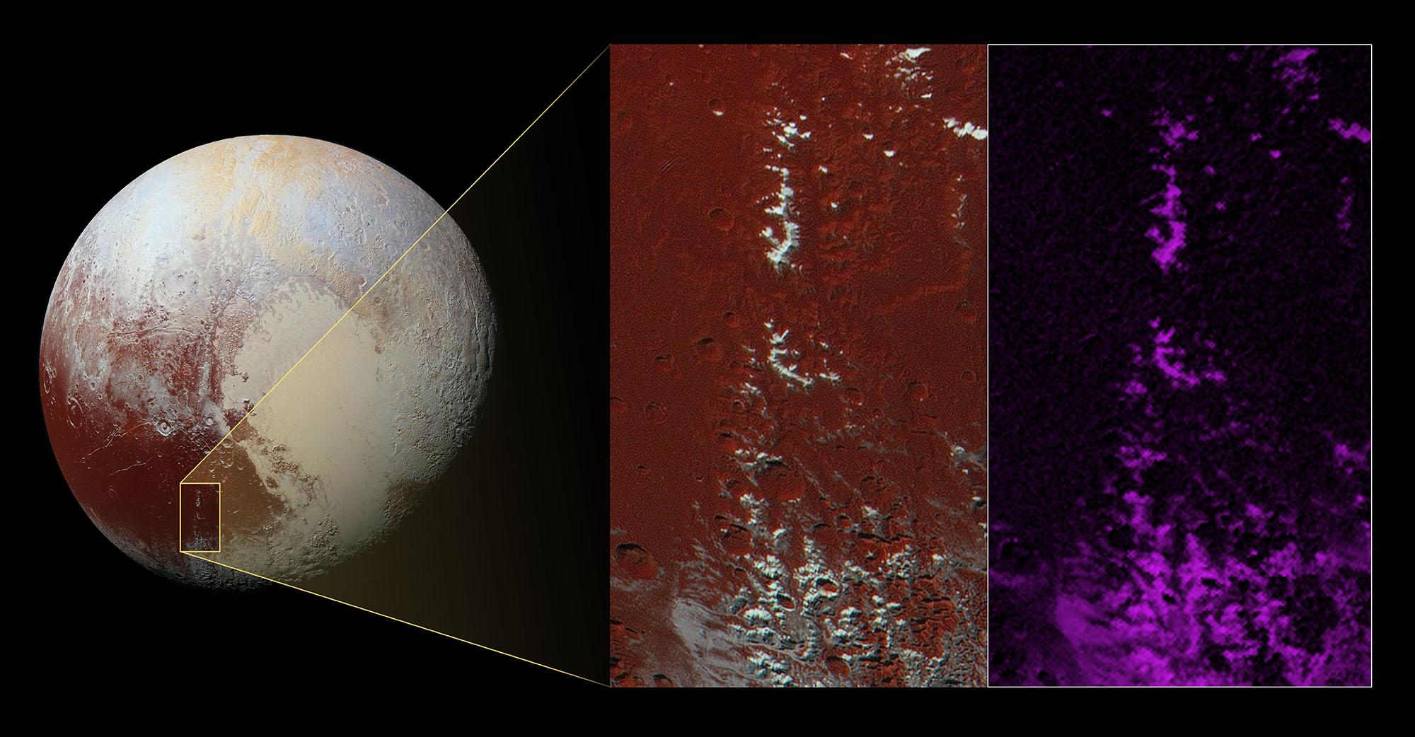
A chain of snow-capped mountains stretches across the dark expanse on Pluto informally named Cthulhu Regio.
Cthulhu (pronounced "k-thu-lu") extends nearly halfway around Pluto's equator, starting to the west of the great nitrogen ice plains informally named Sputnik Planum (see color image of Pluto below). Cthulhu measures approximately 1,850 miles (3,000 kilometers) long and 450 miles (750 kilometers) wide, and with an area of more than 700,000 square miles (1.8 million square kilometers) it's a little larger than Alaska.
Cthulhu's appearance is characterized by a dark surface, which scientists think is due to it being covered by a layer of dark tholins - complex molecules that form when methane is exposed to sunlight. Cthulhu's geology exhibits a wide variety of landscapes, from mountainous, to smooth, to heavily cratered and fractured.
The enhanced color image shown as the left-hand inset below reveals a mountain range located in southeast Cthulhu that measures 260 miles (420 kilometers) long. The range is situated among craters, with narrow valleys separating its peaks. The upper slopes of the highest peaks are coated with a bright material that contrasts sharply with the dark red color of the surrounding plains.
Scientists think this bright material could be predominantly methane that has condensed as an ice onto the peaks from Pluto's atmosphere. That this material coats only the upper slopes of the peaks suggests methane ice may act like water in Earth's atmosphere, condensing as frost at high altitude. Compositional data from the Ralph/Multispectral Visible Imaging Camera (MVIC) on NASA's New Horizons spacecraft, shown in the right-most inset, indicates that the location of the bright ice on the mountain peaks correlates almost exactly with the distribution of methane ice (shown in false color as purple) on the mountains.
The resolution of the enhanced color image is about 2,230 feet (680 meters) per pixel. The image measures approximately 280 miles (450 kilometers) long by 140 miles (225 kilometers) wide. It was obtained by New Horizons at a range of approximately 21,100 miles (33,900 kilometers) from Pluto, about 45 minutes before the spacecraft's closest approach to Pluto on July 14, 2015.
The Johns Hopkins University Applied Physics Laboratory in Laurel, Maryland, designed, built, and operates the New Horizons spacecraft, and manages the mission for NASA's Science Mission Directorate. The Southwest Research Institute, based in San Antonio, leads the science team, payload operations and encounter science planning. New Horizons is part of the New Frontiers Program managed by NASA's Marshall Space Flight Center in Huntsville, Alabama.
