NASA and its partners are contributing observations and expertise in response to the April 14-15, 2015 (April 15-16 Japan time), sequence of earthquakes near Kumamoto, Japan. The sequence began with magnitude 6.2 and 6.0 earthquakes, followed a day later by a magnitude 7.0 quake. The earthquakes caused significant regional damage and a humanitarian crisis.
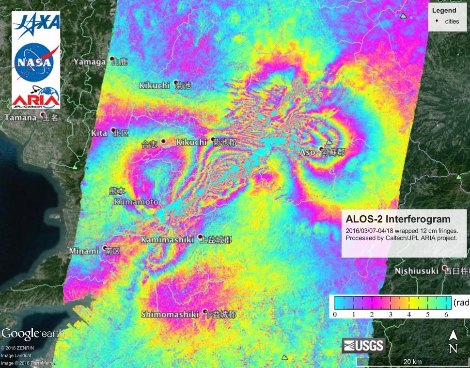
Scientists with the Advanced Rapid Imaging and Analysis project (ARIA), a collaboration between NASA's Jet Propulsion Laboratory, Pasadena, California, and the California Institute of Technology in Pasadena, analyzed interferometric synthetic aperture radar images from the PALSAR-2 instrument on the ALOS-2 satellite operated by the Japan Aerospace Exploration Agency (JAXA) to calculate a map of the deformation of Earth's surface caused by the quake. This false-color map shows the amount of permanent surface movement caused almost entirely by the earthquakes, as viewed by the satellite, during a 42-day interval between two ALOS-2 images acquired on March 7 and April 18, 2016.
In the map, surface displacements are seen as color contours (or "fringes"), where each color cycle represents 4.7 inches (11.9 centimeters) of surface motion. The contours show the land around Kumamoto and along the Futagawa Fault running toward the Aso volcano has moved in a complex pattern. Areas without the color contours have snow or heavy vegetation that affect the radar measurements. Scientists use these maps to build detailed models of the fault and associated land movements to better understand the impact on future earthquake activity. The PALSAR-2 data were provided by JAXA through their science research announcements. The background image is from Google Earth.
For more information about ARIA, visit: http://http://aria.jpl.nasa.gov.
