PIA20376: Peruvian Geometric Geoglyphs Detected by NASA's UAVSAR
 Target Name:  Earth
 Is a satellite of:  Sol (our sun)
 Mission:  UAVSAR
 Instrument:  L-Band UAVSAR
 Product Size:  1041 x 1043 pixels (w x h)
 Produced By:  JPL
 Full-Res TIFF:  PIA20376.tif (3.339 MB)
 Full-Res JPEG:  PIA20376.jpg (226.5 kB)

Click on the image above to download a moderately sized image in JPEG format (possibly reduced in size from original)

Original Caption Released with Image:

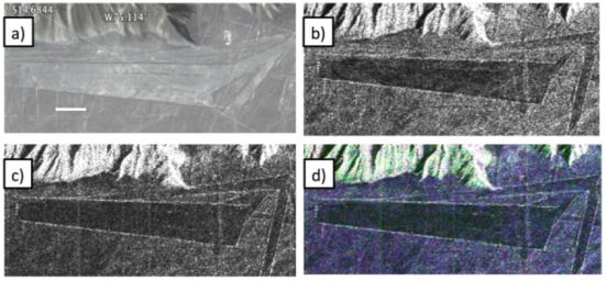
Different visualizations of an area with geometric geoglyphs at the Nasca World Heritage Site in Peru. North is toward the upper right. a) Google Earth image © 2015 Digital Globe showing geometric geoglyphs. The white line indicates 100 meters. b) HH polarization image from NASA's Uninhabited Aerial Vehicle Synthetic Aperture Radar (UAVSAR). c) UAVSAR HV polarization image. d) Color composite of UAVSAR HH (red), HV (green), and VV (blue) images.

The edges of the geometric geoglyph in the SAR images are bright. This is predominately due to the increased roughness of the edges due to the mound of rocks piled there, but is also additionally enhanced if the radar look direction is oriented parallel to the flight path. With this orientation, the fraction of diffusely scattered radiation is more preferentially scattered back toward the side-looking UAVSAR. Meanwhile, the interior of the geoglyph is darker due to the relatively sparse rock density, which results in reduced surface roughness apparent to the L-band radiation and therefore reduced backscattered radar power. This is especially true for the HH and VV polarimetric image.

NASA's Uninhabited Aerial Vehicle Synthetic Aperture Radar (UAVSAR), developed and managed by the Jet Propulsion Laboratory, Pasadena, California, can record changes on the ground beneath the aircraft that occur between multiple flights, which take exactly the same flight path. The instrument is used to monitor how volcanoes, earthquakes, and other natural hazards are changing Earth. Principal investigator Bruce Chapman of JPL noted that UAVSAR is ideally suited for observing the Nasca site because the region has virtually no vegetation and receives no rainfall whatsoever in most years, meaning that natural disturbances are minimal.

Image Credit:
NASA/JPL-Caltech/2015 Google, Digital Globe

Image Addition Date:
2016-02-05