PIA20009: NASA Studying 2015 El Niņo Event as Never Before
 Target Name:  Earth
 Is a satellite of:  Sol (our sun)
 Mission:  OSTM/Jason-2
 Spacecraft:  OSTM/Jason-2
 Instrument:  Altimeter 
 Product Size:  3300 x 1791 pixels (w x h)
 Produced By:  JPL
 Full-Res TIFF:  PIA20009.tif (6.183 MB)
 Full-Res JPEG:  PIA20009.jpg (459.8 kB)

Click on image above for all movie download options

Original Caption Released with Image:

Click here for animation of PIA19648
Click on the image for larger animation

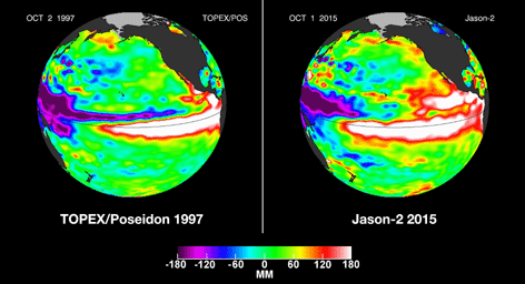
In this side-by-side visualization, Pacific Ocean sea surface height anomalies during the 1997-98 El Niño (left) are compared with 2015 Pacific conditions (right). The 1997 data are from the NASA/CNES Topex/Poseidon mission; the current data are from the NASA/CNES/NOAA/EUMETSAT Jason-2 mission.

Every two to seven years, an unusually warm pool of water -- sometimes 4 to 5 degrees Fahrenheit (2 to 3 degrees Celsius) higher than normal -- develops across the eastern tropical Pacific Ocean to create a natural short-term climate change event. This warm condition, known as El Niño, affects the local aquatic environment, but also spurs extreme weather patterns around the world, from flooding in California to droughts in Australia. This winter, the 2015-16 El Niño event will be better observed from space than any previous El Niño.

The comings and goings of El Niño and La Niña are part of the long-term, evolving state of global climate, for which measurements of sea surface height are a key indicator. Jason-2 is a joint effort between NASA, the National Oceanic and Atmospheric Administration (NOAA), the French Space Agency Centre National d'Etudes Spatiales (CNES) and the European Organisation for the Exploitation of Meteorological Satellites (EUMETSAT). JPL manages the U.S. portion of Jason-2 for NASA's Science Mission Directorate, Washington, D.C. In early 2015, NASA and its international partners CNES, NOAA and EUMETSAT will launch Jason-3, which will extend the timeline of ocean surface topography measurements begun by the Topex/Poseidon and Jason 1 and 2 satellites. Jason-3 will make highly detailed measurements of sea level on Earth to gain insight into ocean circulation and climate change. JPL is a division of the California Institute of Technology.

Photojournal Note: The Jason-3 launch date is Sunday, Jan. 17, 2016, 10:42 A.M. PST.

Image Credit:
NASA/JPL-Caltech

Image Addition Date:
2015-10-19