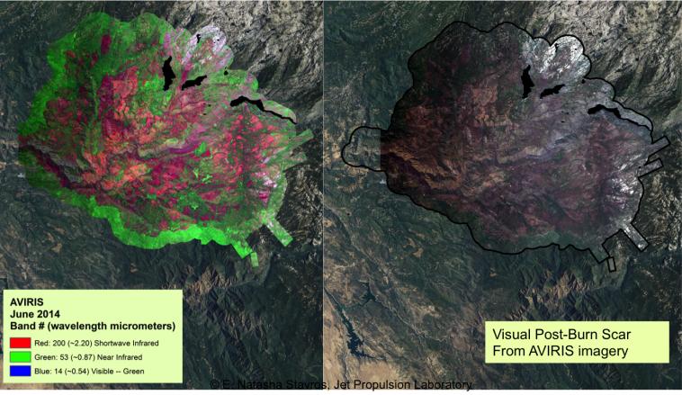
At left, an AVIRIS map shows the spectral signature of the 2013 Rim fire in and near Yosemite National Park, California, the third largest in the state's history, burning more than 250,000 acres. Almost two years later, forest restoration efforts are still ongoing. Charred wood has a strong signal in the wavelengths shown here in red, so areas that are predominantly red in the image were heavily burned. The wavelengths of green, visible light (the color of vegetation) appear on this map as blue. There are no solid blue patches on the map because no large areas of green, living foliage survived the fire. Purple, a mixture of red and blue, indicates an area where charred wood and living plants are mingled. This image provides far more information about the state of the post-fire vegetation than the view on the right, which is what an observer flying overhead would see.
AVIRIS is a unique NASA science instrument that measures the complete solar reflected portion of the electromagnetic spectrum with unmatched spectral range, calibration accuracy and signal-to-noise ratio. AVIRIS spectra are measured from 370 to 2,500 nanometers at 9.8-nanometer intervals. Images are acquired with 20-, 6- or 4-meter (66-, 20, or 13-feet) spatial resolution with a 34 degree swath. Up to 100 million spectra are measured in image format on each flight. The spectral image measurements are provided in orthorectified (geometrically corrected) format for direct use by scientists.
For more information on AVIRIS, visit http://aviris.jpl.nasa.gov/.