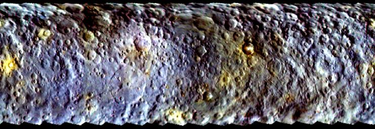
This map-projected view of Ceres was created from images taken by NASA's Dawn spacecraft during its initial approach to the dwarf planet, prior to being captured into orbit in March 2015.
The map is an enhanced color view that offers an expanded range of the colors visible to human eyes. Scientists use this technique in order to highlight subtle color differences across Ceres. This can provide valuable insights into the physical properties and composition of materials on the surface. For example, scientists have not established clear connections between impact craters and the different colors visible here, but they are investigating this possibility.
Images taken using blue (440 nanometers), green (550 nanometers) and infrared (920 nanometers) spectral filters were combined to create the map. The filters were assigned to color channels in reverse order, compared to natural color; in other words, the short-wavelength blue images were assigned to the red color channel and the long-wavelength infrared images are assigned to the blue color channel.
The Dawn mission is managed by NASA's Jet Propulsion Laboratory, Pasadena, California, for NASA's Science Mission Directorate in Washington. Dawn is a project of the directorate's Discovery Program, managed by NASA's Marshall Space Flight Center in Huntsville, Alabama. The University of California, Los Angeles, is responsible for overall Dawn mission science. Orbital ATK, Inc., in Dulles, Virginia, designed and built the spacecraft. The German Aerospace Center, the Max Planck Institute for Solar System Research, the Italian Space Agency and the Italian National Astrophysical Institute are international partners on the mission team.The Dawn mission is managed by NASA's Jet Propulsion Laboratory, Pasadena, California, for NASA's Science Mission Directorate in Washington. Dawn is a project of the directorate's Discovery Program, managed by NASA's Marshall Space Flight Center in Huntsville, Alabama. The University of California, Los Angeles, is responsible for overall Dawn mission science. Orbital ATK, Inc., in Dulles, Virginia, designed and built the spacecraft. The German Aerospace Center, the Max Planck Institute for Solar System Research, the Italian Space Agency and the Italian National Astrophysical Institute are international partners on the mission team. For a complete list of acknowledgments, http://dawn.jpl.nasa.gov/mission.

 Planetary Data System


