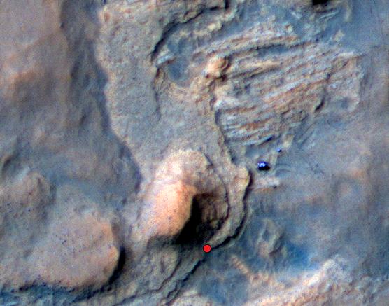
On this view of the Curiosity rover mission's waypoint called "the Kimberley," the red dot indicates the location of a sandstone target, "Windjana," that researchers selected for close-up inspection and possibly for drilling.
The view is an excerpt from an April 11, 2014, observation by the High Resolution Imaging Science Experiment (HiRISE) camera on NASA's Mars Reconnaissance Orbiter. A larger scene from the same observation is at https://photojournal.jpl.nasa.gov/catalog/PIA18081. In the image's enhanced color, Curiosity itself appears as the bright blue object at the two-o'clock position relative to the butte in the lower center of the scene. That butte is called "Mount Remarkable" and stands about 16 feet (5 meters) high. The rover subsequently drove to within its robotic arm's reach of Windjana. For scale, the distance between the parallel wheel tracks visible in the image is about 9 feet (2.7 meters).
In the area of the Kimberley waypoint, sandstone outcrops with differing resistance to wind erosion result in a stair-step pattern of layers. Windjana is within what the team calls the area's "middle unit," because it is intermediate between rocks that form buttes in the area and lower-lying rocks that show a pattern of striations.
If Windjana meets criteria set by engineers and scientists, it could become the mission's third drilled rock and the first that is not mudstone.
This view is an enhanced-color product from HiRISE observation ESP_036128_1755, available at the HiRISE website at http://uahirise.org/releases/msl-kimberley.php. The exaggerated color, to make differences in Mars surface materials more apparent, makes Curiosity appear bluer than the rover really looks.
HiRISE is one of six instruments on NASA's Mars Reconnaissance Orbiter. The University of Arizona, Tucson, operates HiRISE, which was built by Ball Aerospace & Technologies Corp., Boulder, Colo. NASA's Jet Propulsion Laboratory, a division of the California Institute of Technology in Pasadena, manages the Mars Reconnaissance Orbiter and Mars Science Laboratory projects for NASA's Science Mission Directorate, Washington. JPL designed and built the Mars Science Laboratory Project's Curiosity rover.
More information about Curiosity is online at http://www.nasa.gov/msl and http://mars.jpl.nasa.gov/msl/.
 Planetary Data System


