- Original Caption Released with Image:
-

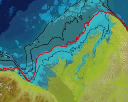
Click the image to play the animationThis movie depicts the role that seafloor topography plays in maintaining the sea ice stuck along the shoreline of Canada's Mackenzie River delta, which holds back and delays the discharge of warm water from the Mackenzie River into the Arctic Ocean. The stuck sea ice appears as a blue band in this map, created with data from the Moderate Resolution Imaging Spectroradiometer (MODIS) instrument on NASA's Terra spacecraft on June 14, 2012. The map fades away, revealing the depth of the seafloor below the sea ice. The highlighted contour line, which represents a depth of 25 meters, coincides with the outer edge of the stuck sea ice. A similar feature was also observed in 2013.
- Image Credit:
-
NASA/International Bathymetric Chart of the Arctic Ocean, Version 3.0
Image Addition Date: -
2014-03-05
|
