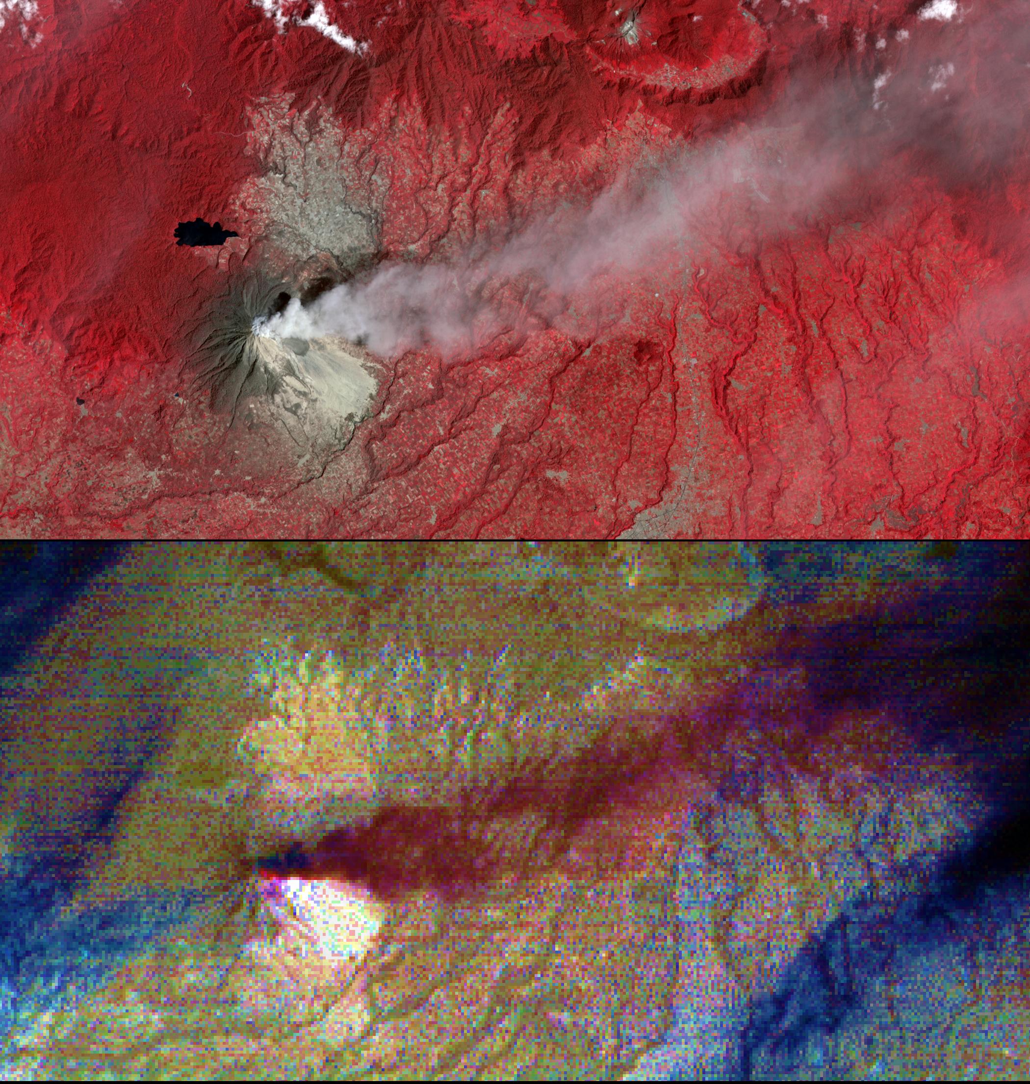
Mount Sinabung is a stratovolcano located in Indonesia. In late 2013, a lava dome formed on the summit. In early January 2014, the volcano erupted, and it erupted again in early February. Tall ash columns deposited material over a wide area; pyroclastic flows rumbled down the volcano's slopes,engulfing villages and resulting in fatalities.
On Feb. 10, 2014, the Advanced Spaceborne Thermal Emission and Reflection Radiometer (ASTER) instrument on NASA's Terra spacecraft captured an image of Sinabung: the top image depicts vegetation in red; an ash plume is light gray streaming eastward from the summit; light-colored areas on the southeast flank are pyroclastic and ash deposits. The bottom image is a composite of ASTER thermal infrared bands: the plume is in purple, indicating that its composition is mostly ash; the white triangular area is hotter than the surrounding materials; blue streaks are water clouds. The images cover an area of 10.3 by 19.6 miles (16.5 by 31.5 kilometers), and are centered at 3.2 degrees north, 98.4 degrees east.
With its 14 spectral bands from the visible to the thermal infrared wavelength region and its high spatial resolution of 15 to 90 meters (about 50 to 300 feet), ASTER images Earth to map and monitor the changing surface of our planet. ASTER is one of five Earth-observing instruments launched Dec. 18, 1999, on Terra. The instrument was built by Japan's Ministry of Economy, Trade and Industry. A joint U.S./Japan science team is responsible for validation and calibration of the instrument and data products.
The broad spectral coverage and high spectral resolution of ASTER provides scientists in numerous disciplines with critical information for surface mapping and monitoring of dynamic conditions and temporal change. Example applications are: monitoring glacial advances and retreats; monitoring potentially active volcanoes; identifying crop stress; determining cloud morphology and physical properties; wetlands evaluation; thermal pollution monitoring; coral reef degradation; surface temperature mapping of soils and geology; and measuring surface heat balance.
The U.S. science team is located at NASA's Jet Propulsion Laboratory, Pasadena, Calif. The Terra mission is part of NASA's Science Mission Directorate, Washington, D.C.
More information about ASTER is available at http://asterweb.jpl.nasa.gov/.
