PDS logoPlanetary Data System
PDS Information
Find a Node - Use these links to navigate to any of the 8 publicly accessible PDS Nodes.

This bar indicates that you are within the PDS enterprise which includes 6 science discipline nodes and 2 support nodes which are overseen by the Project Management Office at NASA's Goddard Space Flight Center (GSFC). Each node is led by an expert in the subject discipline, supported by an advisory group of other practitioners of that discipline, and subject to selection and approval under a regular NASA Research Announcement.
Click here to return to the Photojournal Home Page Click here to view a list of Photojournal Image Galleries Photojournal_inner_header
Latest Images  |  Spacecraft & Technology  |  Animations  |  Space Images App  |  Feedback  |  Photojournal Search  

PIA17588: 'Murray Ridge' in Stereo from Mars Rover Opportunity
 Target Name:  Mars
 Is a satellite of:  Sol (our sun)
 Mission:  Mars Exploration Rover (MER)
 Spacecraft:  Opportunity
 Instrument:  Navigation Camera
 Product Size:  3985 x 1776 pixels (w x h)
 Produced By:  JPL
 Other  
Information: 
You will need 3D glasses
 Full-Res TIFF:  PIA17588.tif (21.24 MB)
 Full-Res JPEG:  PIA17588.jpg (747.4 kB)

Click on the image above to download a moderately sized image in JPEG format (possibly reduced in size from original)

Original Caption Released with Image:

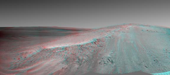
This stereo view shows the "Murray Ridge" portion of the western rim of Endeavour Crater on Mars. It appears three-dimensional when seen through blue-red glasses with the red lens on the left. NASA's Mars Exploration Rover Opportunity used its navigation camera (Navcam) to capture the component exposures for this scene during the 3466 Martian day, or sol, of the rover's mission on Mars (Oct, 24, 2013).

The ridge rises about 130 feet (40 meters) above the surrounding plain, between "Solander Point" at the north end of the ridge and "Cape Tribulation," beyond Murray Ridge to the south. This view does not show the entire ridge. To the left of the ridge, the view stretches across Endeavour Crater, which is about 22 kilometers (14 miles) in diameter.

The scene sweeps from east to south. The planar rocks in the foreground at the base of the hill are part of a layer of rocks laid down around the margins of the crater rim. At this location Opportunity is sitting at the contact between the Meridiani Planum sandstone plains and the rocks of the Endeavour Crater rim. On the upper left, the view is directed about 22 kilometers (14 miles) across the center of Endeavour crater to the eastern rim.

Opportunity landed on Mars in January 2004 and has been investigating parts of Endeavour's western rim since August 2012. On Sol 3451 (Oct. 8, 2013), Opportunity began climbing the ridge. The slope offers outcrops that contain clay minerals detected from orbit and also gives the rover a northward tilt that provides a solar-energy advantage during the Martian southern hemisphere's autumn and winter.

The rover team chose to call this feature Murray Ridge in tribute to Bruce Murray (1931-2013), an influential advocate for planetary exploration who was a member of the science teams for NASA's earliest missions to Mars and later served as director of NASA's Jet Propulsion Laboratory.

Image Credit:
NASA/JPL-Caltech

Image Addition Date:
2013-11-13