PDS logoPlanetary Data System
PDS Information
Find a Node - Use these links to navigate to any of the 8 publicly accessible PDS Nodes.

This bar indicates that you are within the PDS enterprise which includes 6 science discipline nodes and 2 support nodes which are overseen by the Project Management Office at NASA's Goddard Space Flight Center (GSFC). Each node is led by an expert in the subject discipline, supported by an advisory group of other practitioners of that discipline, and subject to selection and approval under a regular NASA Research Announcement.
Click here to return to the Photojournal Home Page Click here to view a list of Photojournal Image Galleries Photojournal_inner_header
Latest Images  |  Spacecraft & Technology  |  Animations  |  Space Images App  |  Feedback  |  Photojournal Search  

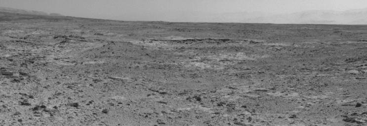
PIA17580: Curiosity's View of "Cooperstown" Outcrop on Route to Mount Sharp
 Target Name:  Mars
 Is a satellite of:  Sol (our sun)
 Mission:  Mars Science Laboratory (MSL)
 Spacecraft:  Curiosity
 Instrument:  Navcam (MSL)
 Product Size:  1323 x 456 pixels (w x h)
 Produced By:  JPL
 Full-Res TIFF:  PIA17580.tif (604.1 kB)
 Full-Res JPEG:  PIA17580.jpg (97.89 kB)

Click on the image above to download a moderately sized image in JPEG format (possibly reduced in size from original)

Original Caption Released with Image:

The low ridge that appears as a dark band below the horizon in the center of this scene is a Martian outcrop called "Cooperstown," a possible site for contact inspection with tools on the robotic arm of NASA's Mars rover Curiosity. The ridge extends roughly 100 feet (about 30 meters) from left to right, and it is about 260 feet (about 80 meters) away from the location from which Curiosity captured this view.

The image combines portions of two frames taken by the Navigation Camera (Navcam) on Curiosity on the 437th Martian day, or sol, of the rover's mission inside Gale Crater on Mars (Oct. 28, 2013).

Curiosity had just completed the mission's first use of two-sol autonomous driving. It resumed autonomous driving on Sol 437 where it had left off driving on Sol 436 (Oct. 27, 2013). In autonomous driving, the rover itself chooses the best route to reach designated waypoints, using onboard analysis of stereo images that it takes during pauses in the drive. The combined two-sol drive that brought Curiosity to this vantage point, for seeing Cooperstown, covered about 410 feet (125 meters).

The left edge of the scene is toward south-southwest, with an edge of Mount Sharp on the horizon; the right edge is toward the west, with part of the rim of Gale Crater on the horizon.

NASA's Jet Propulsion Laboratory, a division of the California Institute of Technology, Pasadena, manages the Mars Science Laboratory Project for NASA's Science Mission Directorate, Washington. JPL designed and built the project's Curiosity rover.

More information about Curiosity is online at http://www.nasa.gov/msl and http://mars.jpl.nasa.gov/msl/.

Image Credit:
NASA/JPL-Caltech

Image Addition Date:
2013-10-29