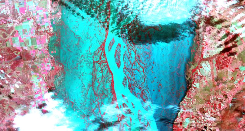
Heavy rains, which began in mid-June, have resulted in major flooding along the Parana River in Argentina. Thousands of people have been forced to evacuate their homes in cities along the river. The neighboring countries of Paraguay, Uruguay and Brazil have also been affected. Vegetated areas are shown in shades of red; the river and flooded areas are blue and turquoise; clouds are white and light blue. This image from the Advanced Spaceborne Thermal Emission and Reflection Radiometer (ASTER) instrument, acquired on July 6, 2013, covers an area of 54 by 28.5 kilometers (33.5 by 17.7 miles), and is located at 28.2 degrees south latitude, 59.1 degrees west longitude.
With its 14 spectral bands from the visible to the thermal infrared wavelength region and its high spatial resolution of 15 to 90 meters (about 50 to 300 feet), ASTER images Earth to map and monitor the changing surface of our planet. ASTER is one of five Earth-observing instruments launched Dec. 18, 1999, on Terra. The instrument was built by Japan's Ministry of Economy, Trade and Industry. A joint U.S./Japan science team is responsible for validation and calibration of the instrument and data products.
The broad spectral coverage and high spectral resolution of ASTER provides scientists in numerous disciplines with critical information for surface mapping and monitoring of dynamic conditions and temporal change. Example applications are: monitoring glacial advances and retreats; monitoring potentially active volcanoes; identifying crop stress; determining cloud morphology and physical properties; wetlands evaluation; thermal pollution monitoring; coral reef degradation; surface temperature mapping of soils and geology; and measuring surface heat balance.
The U.S. science team is located at NASA's Jet Propulsion Laboratory, Pasadena, Calif. The Terra mission is part of NASA's Science Mission Directorate, Washington, D.C.
More information about ASTER is available at http://asterweb.jpl.nasa.gov/.