Figure 1
Click on the image for larger versionLightning ignited the Silver Fire in western New Mexico on June 7, 2013. It has since consumed more than 137,000 acres of timber in a rugged area of the Gila National Forest that has not seen large fires for nearly a century. On the morning of June 28, as the fire exploded in intensity, NASA's Terra spacecraft passed over the fire, allowing the NASA Jet Propulsion Laboratory-built Multi-angle Imaging SpectroRadiometer (MISR) instrument on Terra to capture this image of extensive smoke. Two large pulses of fire generated pyro-cumulonimbus clouds. Brownish smoke, visible to the northwest of the active fire area, has entered the lower stratosphere. An active pulse of fire at the eastern end of this smoke is seen to be forming a new pyro-cumulonimbus tower that rises to a height of more than 8.7 miles (14 kilometers).
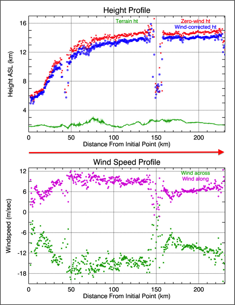
MISR views every scene it passes over from nine different angles. This unique design allows it to measure cloud and aerosol heights and the speed that smoke is moving due to horizontal wind using stereoscopic techniques. The plots in Figure 1 show the height of Silver Fire smoke along a line marked by the red arrow in the image. The profile crosses both smoke clouds, which rise to almost 9.3 miles (15 kilometers) in altitude above sea level (ASL). The lower plot shows the wind speeds retrieved by MISR in the direction across the image swath and in the direction along the satellite track.
These data were acquired during Terra orbit 71959.
MISR was built and is managed by NASA's Jet Propulsion Laboratory, Pasadena, Calif., for NASA's Science Mission Directorate, Washington, D.C. The Terra satellite is managed by NASA's Goddard Space Flight Center, Greenbelt, Md. The MISR data were obtained from the NASA Langley Research Center Atmospheric Science Data Center. JPL is a division of the California Institute of Technology.
