Severe to extreme drought conditions in the Western U.S. have led to a number of large and destructive wildfires in Colorado and New Mexico. The Silver Fire, burning about 30 miles (47 kilometers) east of Silver City, N.M. was ignited by lightning on June 7, 2013, near the historic mining town of Kingston, N.M. At present, the fire continues to grow and has already burned nearly 33 square miles (87 square kilometers or 21,400 acres). Over 500 personnel are working on the fire, which remains uncontained due to the rugged terrain of the Gila National Forest.
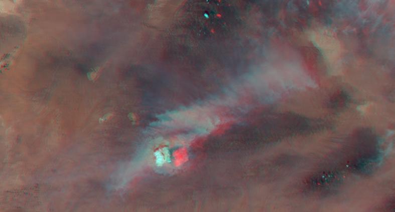
The Multi-angle Imaging SpectroRadiometer (MISR) instrument on NASA's Terra satellite passed over the wildfire at 12:09 p.m. MDT (11:09 p.m. PDT) on June 12, 2013. By combining information from different MISR cameras, scientists have produced a stereo anaglyph of the smoke plume associated with the Silver Fire. The image is best viewed with standard "red/blue" 3-D glasses with the red lens over the left eye. The image is oriented with north to the right. The large white object that appears much higher than the surrounding smoke is a pyrocumulus cloud, which is caused by the intense heating of air by the wildfire, resulting in rapid upward motion of the air until it reaches a level in the atmosphere where condensation can occur.
In this case, MISR stereo retrievals indicate that the pyrocumulus cloud towers over the fire at an altitude of about 7 miles (11 kilometers) above the ground and about 3 miles (4.5 kilometers) above the smoke plume, which can seen extending toward the upper right of the image at an altitude of about 4 miles (5.5 kilometers). The fire is being driven by winds retrieved from MISR observations averaging 26 mph (11.7 meters per second). Weather station observations from Kingston, N.M. at the time of the satellite overpass report a temperature of 95 degrees Fahrenheit (35 degrees Celsius) and with a relative humidity of only 6 percent.
The image extends from about 34.1 to 32.1 degrees north and 108.8 to 107.2 degrees west, covering about 139 miles (223 kilometers) in the north-south direction and 94 miles (151 kilometers) in the east-west direction. The images are a portion of the data acquired during Terra orbit 71726 from blocks 64 to 65 within World Reference System-2 path 35.
MISR was built and is managed by NASA's Jet Propulsion Laboratory, Pasadena, Calif., for NASA's Science Mission Directorate, Washington, D.C. The Terra satellite is managed by NASA's Goddard Space Flight Center, Greenbelt, Md. The MISR data were obtained from the NASA Langley Research Center Atmospheric Science Data Center. JPL is a division of the California Institute of Technology.