PDS logoPlanetary Data System
PDS Information
Find a Node - Use these links to navigate to any of the 8 publicly accessible PDS Nodes.

This bar indicates that you are within the PDS enterprise which includes 6 science discipline nodes and 2 support nodes which are overseen by the Project Management Office at NASA's Goddard Space Flight Center (GSFC). Each node is led by an expert in the subject discipline, supported by an advisory group of other practitioners of that discipline, and subject to selection and approval under a regular NASA Research Announcement.
Click here to return to the Photojournal Home Page Click here to view a list of Photojournal Image Galleries Photojournal_inner_header
Latest Images  |  Spacecraft & Technology  |  Animations  |  Space Images App  |  Feedback  |  Photojournal Search  

PIA17078: Opportunity's view of 'Solander Point'
 Target Name:  Mars
 Is a satellite of:  Sol (our sun)
 Mission:  Mars Exploration Rover (MER)
 Spacecraft:  Opportunity
 Instrument:  Panoramic Camera
 Product Size:  1020 x 1022 pixels (w x h)
 Produced By:  Cornell University 
 Full-Res TIFF:  PIA17078.tif (3.129 MB)
 Full-Res JPEG:  PIA17078.jpg (139.6 kB)

Click on the image above to download a moderately sized image in JPEG format (possibly reduced in size from original)

Original Caption Released with Image:

click here for figure 1 for PIA17078click here for figure 2 for PIA17078
False ColorFalse Color Annotated
Click on an individual image for full resolution figures image

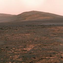
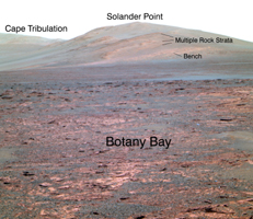
NASA's Mars Exploration Rover Opportunity used its panoramic camera (Pancam) to acquire this view of "Solander Point" during the mission's 3,325th Martian day, or sol (June 1, 2013). The southward-looking scene, presented in true color, shows Solander Point on the center horizon, "Botany Bay" in the foreground, and "Cape Tribulation" in the far background at left.

Botany Bay is a topographic saddle exposing sedimentary rocks that are part of the Burns formation, a geological unit Opportunity examined during earlier years of the mission. At Botany Bay, the Burns formation is exposed between isolated remnants of Endeavour Crater's rim. Solander Point and Cape Tribulation are rim segments south of Botany Bay. Opportunity is on the way to Solander Point to spend the upcoming winter season on northerly tilted surfaces. Extensive rock strata are evident on the northern side of Solander Point, and these ancient rocks and surrounding bench materials will be investigated in detail by Opportunity as part of the winter science campaign.

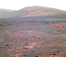
The false-color versions make some differences among geological materials easier to distinguish; these images combine three exposures taken through Pancam filters centered at wavelengths of 753 nanometers, 535 nanometers and 432 nanometers, displayed as red, green and blue colors.

Image Credit:
NASA/JPL-Caltech/Cornell Univ./Arizona State Univ.

Image Addition Date:
2013-06-07