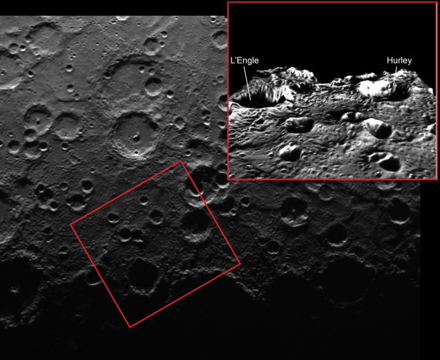
Repeat imaging of Mercury's south pole has revealed that a number of craters in the south contain permanently shadowed regions. Because Mercury has only a very small axial tilt, the topography of crater rims, as accentuated in the inset image (shown with five times the vertical exaggeration of the actual topography), blocks sunlight from ever reaching portions of the floors of some polar craters.
This image features two such permanently shadowed craters which were recently named. Hurley crater, named for Australian James Francis Hurley (1885-1962), photographer of the famous Shackleton Expedition to Antarctica, is 67 km (42 mi.) wide and located within 3° of Mercury's south pole. The slightly smaller (62 km or 39 mi. wide) L'Engle crater is located to the east of Hurley. (Note that in the inset perspective image the view is towards the south). L'Engle crater is named for American author Madeleine L'Engle (1918-2007), best known for her young-adult novels including 'A Wrinkle in Time'. 'A Wrinkle in Time' blends adventure with quantum physics as it follows young heroine Meg on her journey through space to rescue her scientist father.
This primary image was acquired as part of MDIS's campaign to monitor the south polar region of Mercury. By imaging the polar region approximately every four MESSENGER orbits as illumination conditions change, features that were in shadow on earlier orbits can be discerned and any permanently shadowed areas can be identified after repeated imaging over one solar day. During MESSENGER's one-year primary mission, MDIS's WAC was used to monitor the south polar region for the first Mercury solar day (176 Earth days), and MDIS's NAC made repeated images of the south polar region during the second Mercury solar day. The inset image is a portion of the MDIS monochrome map draped over the Gaskell digital elevation model (with 5 times vertical exaggeration), as was also done for Monday's featured image.
Date acquired: August 03, 2011
Image Mission Elapsed Time (MET): 220899377
Image ID: 587366
Instrument: Wide Angle Camera (WAC) of the Mercury Dual Imaging System (MDIS)
WAC filter: 7 (748 nanometers)
Center Latitude: -85.07°
Center Longitude: 67.57° E
Scale: The inset box is about 280 km (174 mi.) wide
Incidence Angle: 85.0°
Emission Angle: 23.4°
Phase Angle: 94.8°
The MESSENGER spacecraft is the first ever to orbit the planet Mercury, and the spacecraft's seven scientific instruments and radio science investigation are unraveling the history and evolution of the Solar System's innermost planet. MESSENGER acquired over 150,000 images and extensive other data sets. MESSENGER is capable of continuing orbital operations until early 2015.
For information regarding the use of images, see the MESSENGER image use policy.