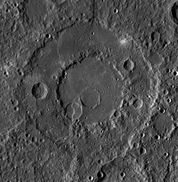
Today's featured image highlights Renoir, one of Mercury's beautiful peak-ring basins. Renoir appears to be older than other basins like Raditladi and Rachmaninoff, with more degradation from subsequent cratering and modification by tectonic activity.
This mosaic was acquired as part of MDIS's high-incidence-angle base map. The high-incidence-angle base map is a major mapping activity in MESSENGER's extended mission and complements the surface morphology base map of MESSENGER's primary mission that was acquired under generally more moderate incidence angles. High incidence angles, achieved when the Sun is near the horizon, result in long shadows that accentuate the small-scale topography of geologic features. The high-incidence-angle base map is being acquired with an average resolution of 200 meters/pixel.
Instrument: Wide Angle Camera (WAC) of the Mercury Dual Imaging System (MDIS)
Latitude Rang: 15° S to 22° S
Longitude Range: 304° E to 312° E
Resolution: 213 meters/pixel
Scale: Renoir is approximately 215 km (134 mi.) in diameter
Projection: Equirectangular
The MESSENGER spacecraft is the first ever to orbit the planet Mercury, and the spacecraft's seven scientific instruments and radio science investigation are unraveling the history and evolution of the Solar System's innermost planet. Visit the Why Mercury? section of this website to learn more about the key science questions that the MESSENGER mission is addressing. During the one-year primary mission, MDIS acquired 88,746 images and extensive other data sets. MESSENGER is now in a year-long extended mission, during which plans call for the acquisition of more than 80,000 additional images to support MESSENGER's science goals.
These images are from MESSENGER, a NASA Discovery mission to conduct the first orbital study of the innermost planet, Mercury. For information regarding the use of images, see the MESSENGER image use policy.

 Planetary Data System


