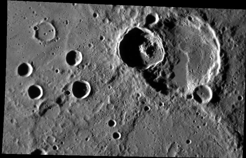
This NAC image features a crater superimposed on a larger crater. Based on the law of superposition, it is apparent that the crater with the central peak is younger than the larger crater because it has destroyed part of the rim of the larger crater. Based on the same principle we can conclude that the scarp is also younger than the larger crater; the scarp cuts across the rim and floor of the larger crater meaning that the larger crater came before the scarp. More analysis would be needed to determine the relative age relationship between the central-peak crater and the scarp. Does the scarp modify the central-peak crater's ejecta, or does the ejecta cover the scarp?
This image was acquired as part of MDIS's high-incidence-angle base map. The high-incidence-angle base map is a major mapping activity in MESSENGER's extended mission and complements the surface morphology base map of MESSENGER's primary mission that was acquired under generally more moderate incidence angles. High incidence angles, achieved when the Sun is near the horizon, result in long shadows that accentuate the small-scale topography of geologic features. The high-incidence-angle base map is being acquired with an average resolution of 200 meters/pixel.
Date acquired: May 26, 2012
Image Mission Elapsed Time (MET): 246558946
Image ID: 1900095
Instrument: Narrow Angle Camera (NAC) of the Mercury Dual Imaging System (MDIS)
Center Latitude: -6.30°
Center Longitude: 259.0° E
Resolution: 198 meters/pixel
Scale: The larger crater is about 51 km (31 miles) in diameter
Incidence Angle: 79.2°
Emission Angle: 51.2°
Phase Angle: 130.5°
This image was acquired as part of MDIS's high-incidence-angle base map. The high-incidence-angle base map is a major mapping activity in MESSENGER's extended mission and complements the surface morphology base map of MESSENGER's primary mission that was acquired under generally more moderate incidence angles. High incidence angles, achieved when the Sun is near the horizon, result in long shadows that accentuate the small-scale topography of geologic features. The high-incidence-angle base map is being acquired with an average resolution of 200 meters/pixel.
These images are from MESSENGER, a NASA Discovery mission to conduct the first orbital study of the innermost planet, Mercury. For information regarding the use of images, see the MESSENGER image use policy.