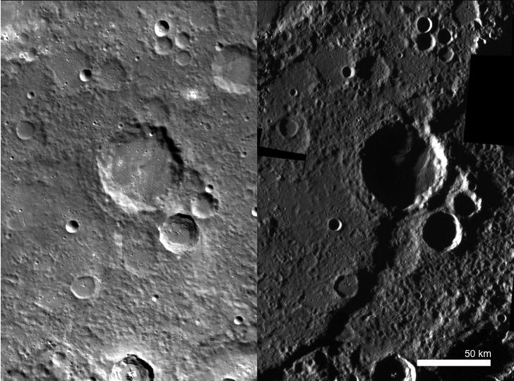
This side-by-side comparison of Discovery rupes under two different illumination conditions illustrates the importance of MESSENGER's various imaging campaigns. The image on the left has an incidence angle, or angle between surface normal and the sun, of approximately 62°, whereas the image on the right has an incidence angle of approximately 85.6°. An incidence angle as high as 85.6° means that the sun is just barely skimming the surface of the planet, providing a unique opportunity to see certain morphological features that are otherwise difficult or impossible to see. For example, Discovery rupes, a sizable scarp that runs over 400 km from end to end, is practically invisible in the monochrome base map image to the left, yet it dominates the high-incidence-angle base map image to the right. This phenomenon has also been illustrated with Basho crater here.
The image on the left was acquired as part of MDIS's high-resolution surface morphology base map. The surface morphology base map will cover more than 90% of Mercury's surface with an average resolution of 250 meters/pixel (0.16 miles/pixel or 820 feet/pixel). Images acquired for the surface morphology base map typically have off-vertical Sun angles (i.e., high incidence angles) and visible shadows so as to reveal clearly the topographic form of geologic features.
The image on the right was acquired as part of MDIS's high-incidence-angle base map. The high-incidence-angle base map is a major mapping activity in MESSENGER's extended mission and complements the surface morphology base map of MESSENGER's primary mission that was acquired under generally more moderate incidence angles. High incidence angles, achieved when the Sun is near the horizon, result in long shadows that accentuate the small-scale topography of geologic features. The high-incidence-angle base map is being acquired with an average resolution of 200 meters/pixel.
Instrument: Mercury Dual Imaging System (MDIS)
Center Latitude: -54.7°
Center Longitude: 322.8° E
Resolution: 200 meters/pixel
Scale: Discovery rupes is 411.9 km (255.9 miles) long.
The MESSENGER spacecraft is the first ever to orbit the planet Mercury, and the spacecraft's seven scientific instruments and radio science investigation are unraveling the history and evolution of the Solar System's innermost planet. Visit the Why Mercury? section of this website to learn more about the key science questions that the MESSENGER mission is addressing. During the one-year primary mission, MDIS acquired 88,746 images and extensive other data sets. MESSENGER is now in a year-long extended mission, during which plans call for the acquisition of more than 80,000 additional images to support MESSENGER's science goals.
These images are from MESSENGER, a NASA Discovery mission to conduct the first orbital study of the innermost planet, Mercury. For information regarding the use of images, see the MESSENGER image use policy.