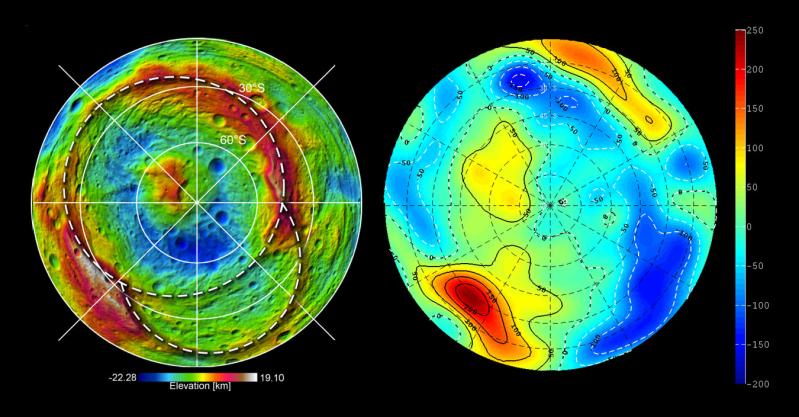
This set of images from NASA's Dawn mission shows topography of the southern hemisphere of the giant asteroid Vesta and a map of Vesta's gravity variations that have been adjusted to account for Vesta's shape. The shaded relief map on the left shows the outlines of the two ancient basins, Rheasilvia and Veneneia. On the right is a map of the residual gravity field created by removing the gravity due to the hills and valleys within the crustal layer, revealing the signature of variations in density.
Red shows the strongest gravitational pull in this scheme, measured in milligal units, and dark blue shows the weakest. Milligals are a unit of acceleration due to gravity. The large central peak of the Rheasilvia basin, which appears as the yellow area just above and to the left of center, has a small positive residual gravity anomaly. This indicates the crust there is denser, coming from deeper within the body, or perhaps is less fractured. The gravity lows near the basin rim on the right, shown in dark blue, likely indicate rock that is lighter as a result of being pulverized by the two impacts.
The topography model is derived from framing camera images from Dawn's high-altitude mapping orbit (420 miles or 680 kilometers above the surface) and the gravity data come from the low-altitude mapping orbit (130 miles or 210 kilometers above the surface).
The Dawn mission to Vesta and Ceres is managed by NASA's Jet Propulsion Laboratory, a division of the California Institute of Technology in Pasadena, for NASA's Science Mission Directorate, Washington. UCLA is responsible for overall Dawn mission science. The Dawn framing cameras were developed and built under the leadership of the Max Planck Institute for Solar System Research, Katlenburg-Lindau, Germany, with significant contributions by DLR German Aerospace Center, Institute of Planetary Research, Berlin, and in coordination with the Institute of Computer and Communication Network Engineering, Braunschweig. The framing camera project is funded by the Max Planck Society, DLR and NASA/JPL.
More information about the Dawn mission is online at http://www.nasa.gov/dawn and http://dawn.jpl.nasa.gov.
 Planetary Data System


