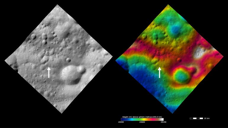
These Dawn FC (framing camera) images show Claudia crater (marked by an arrow) and its surroundings. Claudia crater is the crater which is used to define 0° longitude on Vesta. Claudia crater was chosen for this for many reasons. Firstly, it is in a longitude region of Vesta that does not have many prominent/ significant features. The region in which 0° longitude is defined will be split in two and it is important not to split prominent/ significant features. Secondly, it is located near Vesta's equator and is a small crater (~700m across) so this increases the accuracy of the location of 0° longitude. Thirdly, it is reasonably easy to locate. In order to find it first find the large, ~15km diameter, crater with the ~5km diameter impact crater on its rim. Then find the double degraded craters, which are each ~5km in diameter, and are ~10km east of the ~15km diameter crater. These double craters have a small, <1km diameter, crater on their rim. Claudia is ~3km to the west of this crater. The left image is an albedo image, which is taken directly through the clear filter of the FC. Such an image shows the albedo (eg. brightness/ darkness) of the surface. The right image uses the same albedo image as its base but then a color-coded height representation of the topography is overlain onto it. The topography is calculated from a set of images that were observed from different viewing directions, allowing stereo reconstruction. The various colors correspond to the height of the area. The white and red areas across the center of the image are the highest areas and the blue and green areas in the top and bottom of the image are the lowest areas.
These images are from the Oppia quadrangle and the center latitude and longitude of the image is 0.4°S, 357.9°E. NASA's Dawn spacecraft obtained this image with its framing camera on October 30th 2011. This image was taken through the camera's clear filter. The distance to the surface of Vesta is 700 km and the image has a resolution of about 70 meters per pixel. This image was acquired during the HAMO (High Altitude Mapping Orbit) phase of the mission. The images are lambert-azimuthal map projected.
The Dawn mission to Vesta and Ceres is managed by NASA's Jet Propulsion Laboratory, a division of the California Institute of Technology in Pasadena, for NASA's Science Mission Directorate, Washington D.C. UCLA is responsible for overall Dawn mission science. The Dawn framing cameras have been developed and built under the leadership of the Max Planck Institute for Solar System Research, Katlenburg-Lindau, Germany, with significant contributions by DLR German Aerospace Center, Institute of Planetary Research, Berlin, and in coordination with the Institute of Computer and Communication Network Engineering, Braunschweig. The Framing Camera project is funded by the Max Planck Society, DLR, and NASA/JPL.
More information about Dawn is online at http://dawn.jpl.nasa.gov.