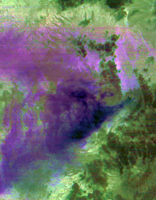
Thermal Infrared Composite
Click on the image for larger versionAfter lying dormant for 70 years, Cotopaxi volcano in Ecuador started erupting the week of Aug. 17, 2015, sending up huge columns of ash that affected towns in the region, including the capital city Quito 31 miles (50 kilometers) away. On Aug. 22, when these images were captured by the Advanced Spaceborne Thermal Emission and Reflection Radiometer (ASTER) instrument on NASA's Terra spacecraft, a gray eruption column could be seen above the volcano on the right-center of the image (vegetation is shown in shades of red). The ash is being dispersed by the winds in a triangular pattern to the west. The thermal infrared composite image reveals that the material is ash (identifiable by the magenta and purple colors), with little water vapor or sulfur dioxide. The image covers an area of 17 by 24 miles (27 by 39 kilometers), and is located at 0.8 degrees south, 78.5 degrees west.
With its 14 spectral bands from the visible to the thermal infrared wavelength region and its high spatial resolution of 15 to 90 meters (about 50 to 300 feet), ASTER images Earth to map and monitor the changing surface of our planet. ASTER is one of five Earth-observing instruments launched Dec. 18, 1999, on Terra. The instrument was built by Japan's Ministry of Economy, Trade and Industry. A joint U.S./Japan science team is responsible for validation and calibration of the instrument and data products.
The broad spectral coverage and high spectral resolution of ASTER provides scientists in numerous disciplines with critical information for surface mapping and monitoring of dynamic conditions and temporal change. Example applications are: monitoring glacial advances and retreats; monitoring potentially active volcanoes; identifying crop stress; determining cloud morphology and physical properties; wetlands evaluation; thermal pollution monitoring; coral reef degradation; surface temperature mapping of soils and geology; and measuring surface heat balance.
The U.S. science team is located at NASA's Jet Propulsion Laboratory, Pasadena, Calif. The Terra mission is part of NASA's Science Mission Directorate, Washington, D.C.
More information about ASTER is available at http://asterweb.jpl.nasa.gov/.

