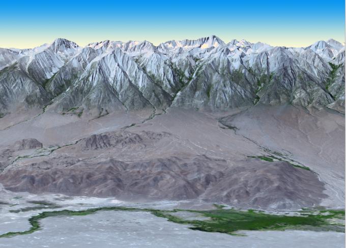
At 14,505 feet (4,421 meters) in elevation, California's Mt. Whitney, located in the Sierra Nevada Mountains on the west side of Owens Valley, is the highest point in the contiguous United States. In this 3-D perspective view looking west, created by the Advanced Spaceborne Thermal Emission and Reflection Radiometer (ASTER) instrument on NASA's Terra spacecraft, the Alabama Hills appear in the foreground. Hundreds of western movies have been filmed here in this scenic and rugged countryside, including 12 starring John Wayne. This view was created by draping the ASTER image over a Digital Elevation Model produced from ASTER stereo data .The ASTER image was acquired July 14, 2011, and is located near 36.6 degrees north latitude, 118.3 degrees west longitude.
With its 14 spectral bands from the visible to the thermal infrared wavelength region and its high spatial resolution of 15 to 90 meters (about 50 to 300 feet), ASTER images Earth to map and monitor the changing surface of our planet. ASTER is one of five Earth-observing instruments launched Dec. 18, 1999, on Terra. The instrument was built by Japan's Ministry of Economy, Trade and Industry. A joint U.S./Japan science team is responsible for validation and calibration of the instrument and data products.
The broad spectral coverage and high spectral resolution of ASTER provides scientists in numerous disciplines with critical information for surface mapping and monitoring of dynamic conditions and temporal change. Example applications are: monitoring glacial advances and retreats; monitoring potentially active volcanoes; identifying crop stress; determining cloud morphology and physical properties; wetlands evaluation; thermal pollution monitoring; coral reef degradation; surface temperature mapping of soils and geology; and measuring surface heat balance.
The U.S. science team is located at NASA's Jet Propulsion Laboratory, Pasadena, Calif. The Terra mission is part of NASA's Science Mission Directorate, Washington, D.C.
More information about ASTER is available at http://asterweb.jpl.nasa.gov/.