 | 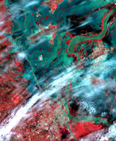 |
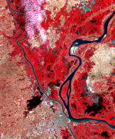
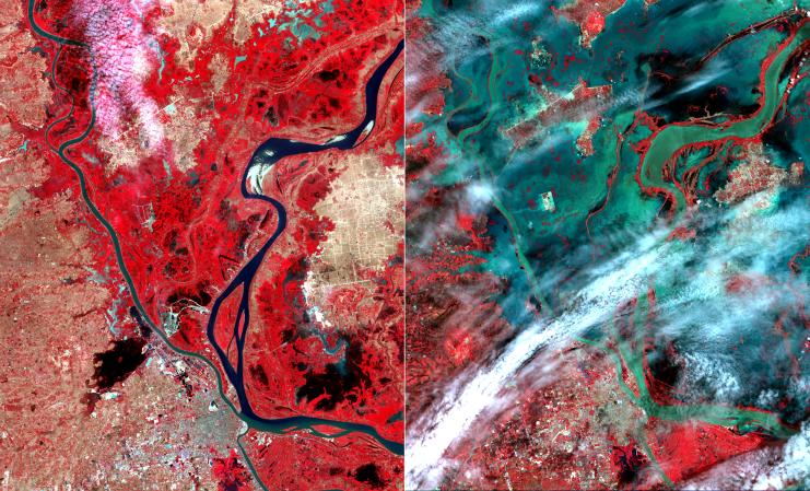
| January 28 | August 24 |
Click on an individual image for full resolution tiff imageIn mid-August 2011, unusually heavy rains over the upper Mekong River in Laos and Thailand led to severe flooding in Cambodia. According to the Phnom Penh Post, thousands of people had been left homeless from rising flood waters. These two images from the Advanced Spaceborne Thermal Emission and Reflection Radiometer (ASTER) instrument on NASA's Terra spacecraft show the city of Phnom Penh at the bottom center of the image. Vegetation is displayed in red, bare ground is light brown, and water is black or dark green where it is relatively clear, and green-blue where it carries large amounts of sediment. The images cover an area of 34.4 by 39 miles (55.5 by 63 kilometers), were acquired on January 28 and August 24, 2011, and are located near 11.7 degrees north latitude, 104.9 degrees east longitude.
With its 14 spectral bands from the visible to the thermal infrared wavelength region and its high spatial resolution of 15 to 90 meters (about 50 to 300 feet), ASTER images Earth to map and monitor the changing surface of our planet. ASTER is one of five Earth-observing instruments launched Dec. 18, 1999, on Terra. The instrument was built by Japan's Ministry of Economy, Trade and Industry. A joint U.S./Japan science team is responsible for validation and calibration of the instrument and data products.
The broad spectral coverage and high spectral resolution of ASTER provides scientists in numerous disciplines with critical information for surface mapping and monitoring of dynamic conditions and temporal change. Example applications are: monitoring glacial advances and retreats; monitoring potentially active volcanoes; identifying crop stress; determining cloud morphology and physical properties; wetlands evaluation; thermal pollution monitoring; coral reef degradation; surface temperature mapping of soils and geology; and measuring surface heat balance.
The U.S. science team is located at NASA's Jet Propulsion Laboratory, Pasadena, Calif. The Terra mission is part of NASA's Science Mission Directorate, Washington, D.C.
More information about ASTER is available at http://asterweb.jpl.nasa.gov/.