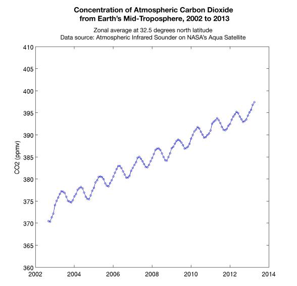
This graph made with data from the Atmospheric Infrared Sounder on NASA's Aqua satellite shows the concentration of carbon dioxide in Earth's mid-troposphere, located roughly between 3 to 6 miles (5 to 9 kilometers) in altitude.
The sawtooth pattern reflects plants "breathing in" carbon dioxide as they grow, removing this gas from the atmosphere. Soil and plants then release carbon dioxide back into the atmosphere when plants die at the end of the growing season. The upward slope of the graph shows the continuous increase in the concentration of carbon dioxide in Earth's atmosphere. In 2002 the AIRS instrument--which collects data around the entire globe every day -- reported the average concentration of carbon dioxide in Earth's mid-troposphere to be 372 parts per million (ppm). In 2013, AIRS reported April's average daily global concentration in this region to be 397 ppm.
The concentration of carbon dioxide in the mid-troposphere lags the concentration found at Earth's surface as mixing from the lower to upper altitudes usually takes days to weeks. In addition, changes in concentration of carbon dioxide at Earth's surface are not always carried up to higher altitudes.
While AIRS is able to detect carbon dioxide in Earth's atmosphere to an accuracy of 4 parts per million (ppm), the precision of the measurement clearly corroborates the roughly 2 ppm annual increase in the concentration of this greenhouse gas.
About AIRS
The Atmospheric Infrared Sounder, AIRS, in conjunction with the Advanced Microwave Sounding Unit, AMSU, senses emitted infrared and microwave radiation from Earth to provide a three-dimensional look at Earth's weather and climate. Working in tandem, the two instruments make simultaneous observations all the way down to Earth's surface, even in the presence of heavy clouds. With more than 2,000 channels sensing different regions of the atmosphere, the system creates a global, three-dimensional map of atmospheric temperature and humidity, cloud amounts and heights, greenhouse gas concentrations, and many other atmospheric phenomena. Launched into Earth orbit in 2002, the AIRS and AMSU instruments fly onboard NASA's Aqua spacecraft and are managed by NASA's Jet Propulsion Laboratory in Pasadena, Calif., under contract to NASA. JPL is a division of the California Institute of Technology in Pasadena.
More information about AIRS can be found at http://airs.jpl.nasa.gov.
 Planetary Data System


