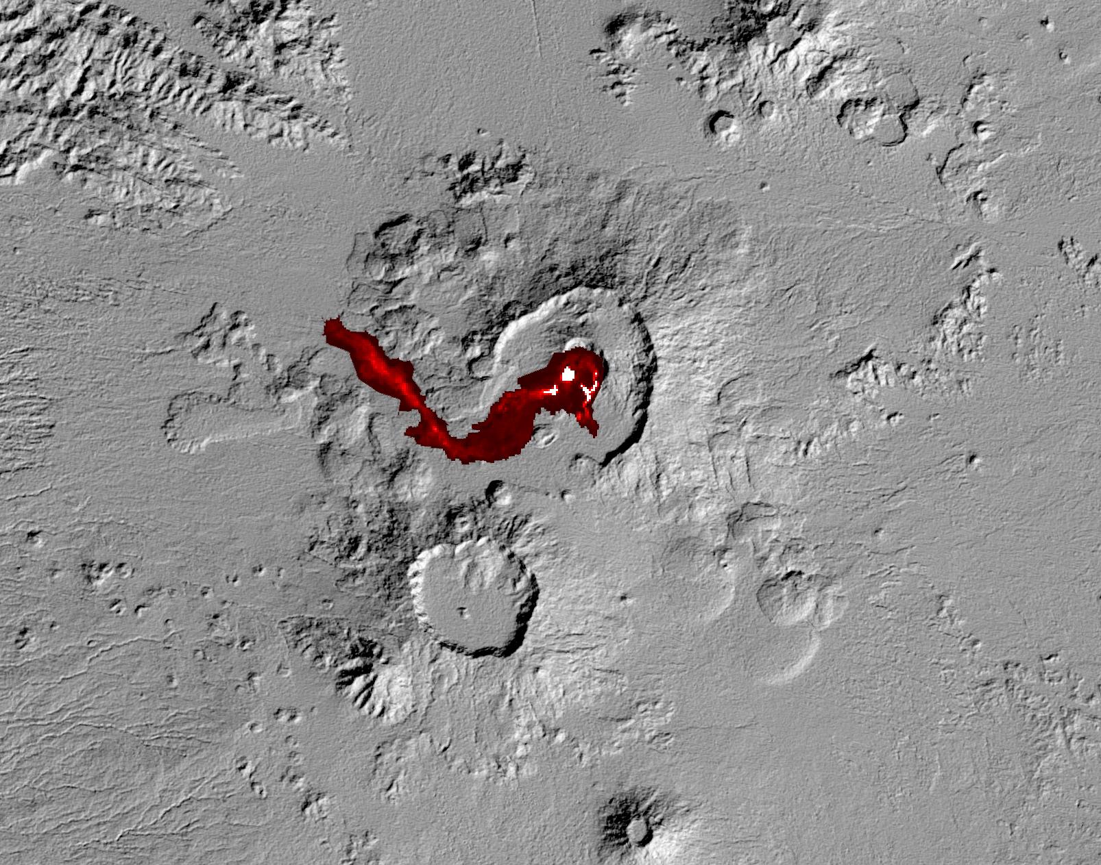
Nabro volcano in the African nation of Eritrea began erupting June 12, 2011 -- the first-ever recorded eruption of this stratovolcano. Ash plumes sent into the stratosphere disrupted air traffic in Sudan, Djibouti, Ethiopia and Sudan for the next week. The continuing eruption is seen in this July 5, 2011, nighttime thermal image acquired by the Advanced Spaceborne Thermal Emission and Reflection Radiometer (ASTER) instrument on NASA's Terra spacecraft. Hot lava flows and lava in the summit crater are displayed in shades of red and white. The background is a shaded relief image created from ASTER's Global Digital Elevation Model data set. Nabro is located along Africa's Great Rift Valley, along with other volcanoes. The image covers an area of 30 by 24 miles (48 by 38 kilometers), and is located at 13.4 degrees north latitude, 41.7 degrees east longitude. The image resolution is 94 feet (30 meters).
With its 14 spectral bands from the visible to the thermal infrared wavelength region and its high spatial resolution of 15 to 90 meters (about 50 to 300 feet), ASTER images Earth to map and monitor the changing surface of our planet. ASTER is one of five Earth-observing instruments launched Dec. 18, 1999, on Terra. The instrument was built by Japan's Ministry of Economy, Trade and Industry. A joint U.S./Japan science team is responsible for validation and calibration of the instrument and data products.
The broad spectral coverage and high spectral resolution of ASTER provides scientists in numerous disciplines with critical information for surface mapping and monitoring of dynamic conditions and temporal change. Example applications are: monitoring glacial advances and retreats; monitoring potentially active volcanoes; identifying crop stress; determining cloud morphology and physical properties; wetlands evaluation; thermal pollution monitoring; coral reef degradation; surface temperature mapping of soils and geology; and measuring surface heat balance.
The U.S. science team is located at NASA's Jet Propulsion Laboratory, Pasadena, Calif. The Terra mission is part of NASA's Science Mission Directorate, Washington, D.C.
More information about ASTER is available at http://asterweb.jpl.nasa.gov/.
